A place
Bribie Island & the Pumicestone Passage
A long, sheltered tidal passage between a sand island and the mainland — seagrass in the shallows, mangrove along the banks, wide wader flats at low tide, wallum on the island's sand, and the Glass House Mountains standing over the lot: a whole estuary read in one calm run of water.
- On the gradient
- The bottom of the gradient — a sheltered estuarine tidal passage between a sand island and the mainland, backed by wallum sand and the range beyond
- Rock
- Quaternary coastal sand (Bribie Island barrier-island sand mass) fronting a sheltered tidal passage; Glass House Mountains volcanic plugs inland
- Soil
- Deeply leached podzol on the island sand (wallum); estuarine mud and sand on the passage floor and flats
- A long, narrow strip of salt water between the mainland and a sandy island
- Calm water, barely moving, with no surf — sheltered, not open coast
- Meadows of a green, grass-like plant in the clear shallows over sand
- A fringe of low dark trees along the muddy banks, and wide wader flats bared at low tide
The Pumicestone Passage is a long, narrow, quiet stretch of tidal water that runs between the mainland and Bribie Island, a low sand island lying just off the coast. Because the island shelters it from the open sea, the passage is calm salt water rather than surf, and it grows the full estuary in bands: pale seagrass meadows in the clear shallows, mangroves along the muddy banks, and wide flats of mud and sand that drain at low tide and feed the wading birds. The island itself is bleached sand carrying wallum heath, and the whole scene sits under the Glass House Mountains. It is estuary country of the highest grade — a Ramsar-listed, marine-park-protected passage — and one of the calmest places on the coast to read a tidal world whole.
Come to the water on a falling tide at, say, the Caloundra end of the Pumicestone Passage, and the first thing you notice is how still it is. There is salt in it, and the tide is dropping steadily away from your feet, but there is no surf, because a long low island of sand — Bribie — lies out between you and the open sea and takes the ocean’s blows on its own beach. What that shelter buys is a calm, and in the calm the whole estuary spreads out to be read, band by band, like a diagram someone has drawn across the water.
In the clear shallows over pale sand there are meadows of seagrass, the flowering plant that pastures the inshore sea and hides a generation of young fish and prawns among its blades. Along the softer banks stands the mangrove, breathing through its thousands of pencil roots and dropping the leaves that feed everything downstream of them. And where the tide pulls right back it lays bare wide flats of mud and sand, apparently empty and in fact crawling with buried life — the fuel stop for shorebirds that fly in from the Arctic. Each of those bands lives exactly where the salt and the soaking let it, the tidal version of the great slope that orders the whole coast. This is a sheltered estuary reading itself out loud.
Then look at the island doing the sheltering, because it is built of the opposite lesson. Bribie is bleached sand almost all the way down, leached over tens of thousands of years until barely a trace of nutrient survives, and so it carries wallum — the hard-leaved, banksia-crowned heath that turns bottomless poverty into one of the richest wildflower gardens in the country. Salt on the water, poverty on the island, a few hundred metres apart. And over it all, inland, stand the Glass House Mountains, the worn-down throats of long-dead volcanoes. Hold the passage, the island and those far blue plugs in one glance and you are looking at almost the whole coast at once — reef to range, in a single calm run of tide. It is protected now, as Ramsar wetland and marine park, and reading it whole tells you why: pull any one thread — cloud the water, wall the flats, drop the island’s water table — and the rest begin, quietly, to come apart.
In depth — the mechanism
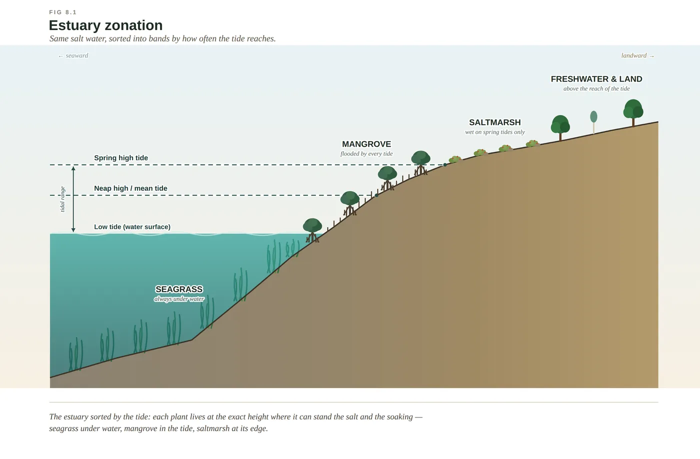
The Pumicestone Passage is the sheltered estuary made long and legible. A low, sandy barrier island — Bribie — lies just off the mainland, and the strip of tidal water trapped between the two is calm where the open coast is surf: salt, but combed twice a day by the tide rather than pounded by waves. That shelter is what lets the estuary lay itself out in full. Read it as the tidal gradient of Chapter 8, run out along a corridor instead of stacked across a few hundred metres of riverbank. In the clear shallows over sand grow the seagrass meadows — true flowering plants, not weed — the underwater pasture and nursery of the inshore sea (see seagrass-meadows). Along the softer banks stands the mangrove fringe, breathing through its snorkel roots and shedding the leaf litter that feeds the whole system. And at low tide the passage bares wide flats of mud and sand, dense with buried worms and crabs, that are the feeding grounds for migratory shorebirds down the East Asian–Australasian Flyway. Each band sits where the salt and the soaking allow it, sorted exactly as the plants of the dunes are sorted by poverty — estuarine-zonation, the great slope compressed and driven by the tide.
The island that makes the shelter is worth reading in its own right, because it is built of the opposite thing. Bribie is a coastal sand mass, and its sand has been leached by rain over tens of thousands of years into a bleached, bottomless podzol — the same slow stripping of nutrient down through the profile that built Cooloola (see podzolisation). So the island carries wallum: hard-leaved heath and wallum banksia on sand that has almost nothing to give, the richest poverty in Australia growing a stone's throw from the richest nursery in the sea. One passage, and two of the coast's headline lessons — salt on one side of the water, poverty on the other — facing each other across a few hundred metres of tide.
The passage matters beyond its beauty. Its seagrass beds are part of why the broader Moreton Bay region carries a nationally significant, strongly seasonal dugong population, and the sheltered waters of the passage are among their year-round haunts — a large, shy grazer staked entirely on a plant that clouded water can kill (McPhee 2017; Davie 1998). The wider bay is recognised internationally as a Ramsar wetland, in large part for those wader flats, and the passage lies within the region's marine park. And over the whole scene, inland, stand the volcanic plugs of the Glass House Mountains — the eroded throats of old volcanoes — so that a single view holds the reef-to-range gradient nearly entire: seagrass, mangrove and mudflat in the foreground, wallum on the island, and the ancient rock of the range on the skyline. Read it as one connected country and the argument for keeping it makes itself: foul the water and the seagrass and the dugong go; drain or wall the flats and the birds lose a link in a chain strung halfway around the world.
Concepts this teaches — follow a thread
Estuarine zonation (the tide sorts the bands)Seagrass meadows (the inshore pasture and nursery)Podzolisation (how sand goes bankrupt)
Sources for this guide — followable
- McPhee, D. (2017). Environmental History and Ecology of Moreton Bay. CSIRO Publishing. — Bay-region estuarine and seagrass ecology; Pumicestone Passage seagrass and its dugong; Moreton Bay Ramsar/marine-park setting.
- Davie, P. (1998). Wild Guide to Moreton Bay. Queensland Museum. — Regional estuarine natural history — mangrove, seagrass, wader flats and the fauna of the sheltered passage.
- Leiper, G. et al. (2022). Mangroves to Mountains (3rd ed.). Native Plants Queensland. — Regional flora — mangrove and seagrass of the passage, and the wallum banksia and heath of the island's leached sand.
Test yourself →
You are standing at the edge of a long, narrow strip of salt water that runs between the mainland and a low, sandy island lying just offshore. The water is calm and barely moving — no surf reaches it. In the clear shallows over pale sand there are meadows of a green, grass-like plant; along the muddy banks stands a fringe of low dark trees; and where the tide has pulled back it has bared wide flats of mud and sand, dotted with wading birds probing for food. What country are you reading — and why does it look like this?
Cues: A long, narrow strip of salt water between the mainland and a sandy island · Calm water, barely moving, with no surf — sheltered, not open coast · Meadows of a green, grass-like plant in the clear shallows over sand · A fringe of low dark trees along the muddy banks, and wide wader flats bared at low tide
Every cue says sheltered and tidal. The strip of salt water lies behind an island that takes the ocean's blows, so it is calm rather than surf — an estuarine passage, not the open coast. The green grass-like meadows in the clear shallows are seagrass (a flowering plant, not seaweed); the low dark trees on the mud are mangrove; and the wide flats bared at low tide, worked by wading birds, are the intertidal feeding grounds. Salt water and a tide line rule out a freshwater lake or swamp; the calm and the mud rule out a surf beach; and the slow, still, banded water rules out a fast rocky river. The bands are sorted by how often the tide reaches — estuarine zonation. (Ch 8; Ch 14 — the Pumicestone Passage is the type example.)
In sheltered, shallow water over sand behind a sand island, you snorkel across broad underwater meadows of strap-leaved plants rooted in the seabed, with flowers and seed among the leaves. What are you reading, and what does this meadow support?
Two cues converge: it is rooted in the sand and it flowers and seeds — so it is not algae. Seagrass is a genuine flowering plant that returned to the sea, spreading its strap leaves into meadows over sheltered sand, and those meadows are the pasture of the shallows: green turtles crop them, and dugong plough them like underwater cattle. The tempting misreading is 'seaweed', because from the surface a green underwater sward looks like weed — but seaweed is an alga with no roots, flowers or seed, and it does not feed a dugong. It is not a coral reef (that is hard bottom built by animals) and not rootless drift-weed. Moreton Bay's meadows support a nationally significant dugong population — several hundred to around a thousand animals, and strongly seasonal, not a fixed number. (Ch 14.)
In an estuary, seagrass grows below the tide, mangrove in the tidal band that floods and drains twice a day, and saltmarsh on the higher flats the tide reaches only occasionally — always in that order. What sets the order of the bands?
Estuarine zonation is the gradient rule driven by the tide. The controlling variable is how often the salt water reaches — hydroperiod — running together with salinity and how airless the mud is. Seagrass takes the always-drowned ground, mangrove the twice-daily tidal band, saltmarsh the rarely-flooded flats; each plant holds the one height where it can just stand the conditions and would drown a step seaward or be outcompeted a step landward. It is not richness or height that sorts them, but tolerance. (Ch 8.)
Cited · traceable Last checked 2026-07. Deep-tier claims rest on, and were checked against, McPhee 2017, Environmental History and Ecology of Moreton Bay; Davie 1998, Wild Guide to Moreton Bay; Leiper et al. 2022, Mangroves to Mountains. Grounded in Ch 8 (estuary zonation — seagrass/mangrove/saltmarsh bands sorted by tidal reach; mangrove snorkel roots; wader flats and the East Asian–Australasian Flyway; Pumicestone Passage seagrass and nationally significant dugong) and Ch 9 (Bribie/Cooloola sand mass podzolisation → wallum on bleached sand). Pumicestone Passage year-round dugong haunt + Moreton Bay Ramsar listing (22 Oct 1993) and marine-park protection per Ch 8/14 Notes; Glass House Mountains volcanic plugs inland. Verified July 2026. — every source is listed below and followable. Grounded in Same Sky, Different Ground.