A force
Deep time — the making of the rock
The first force, and the slowest: fire and drift built the coast out of three raw materials — fertile basalt, quiet sandstone, and the hard plugs of vanished volcanoes — and then handed them to twenty-six million years of weather.
- On the gradient
- The source of the whole gradient — deep time deals the raw ground before any living thing appears
- Rock
- Oligocene volcanic plugs (rhyolite/trachyte) ~26–27 Ma, over Mesozoic Landsborough Sandstone and Palaeozoic basement; Quaternary sand along the coast
- Soil
- Varies by parent rock — red basalt clay on the uplands, thin soils on the older rock, bleached sand on the coast
The blue peaks on the western skyline are the worn-down stumps of old volcanoes. The rich red hinterland soil is rotted lava. The bright coastal sand is younger still. Long before a single plant, deep time dealt this coast three kinds of ground — and what grows where has been following that hand ever since.
On a still morning the Glass House Mountains float blue and serene on the inland horizon, and nothing about the scene suggests violence. Yet those calm peaks are the cooled stumps of volcanoes, the rich red soil of the hinterland is rotted-down lava, and the bright sand of the coast is younger still. Before a single leaf enters the story, deep time has already dealt this coast its hand — and everything that lives here is playing the cards it was given.
The fire made two very different rocks, and the difference decides the rest of the book. Stiff, silica-rich lava clogged the volcanoes’ throats and cooled into plug rock so hard it barely budged while everything around it washed away; those plugs stand today as the signature peaks. Runny, silica-poor lava — basalt — flooded out flat and rots, given rain and time, into the deep red clay that carries rainforest and orchards. One fire built the postcard mountains; the other built the farmland. Then, much later and by water rather than fire, the coast got its third material entirely: quartz sand, swept north grain by grain and heaped into the dunes of Cooloola, some of the youngest land in the country sitting within an hour of some of the oldest rock.
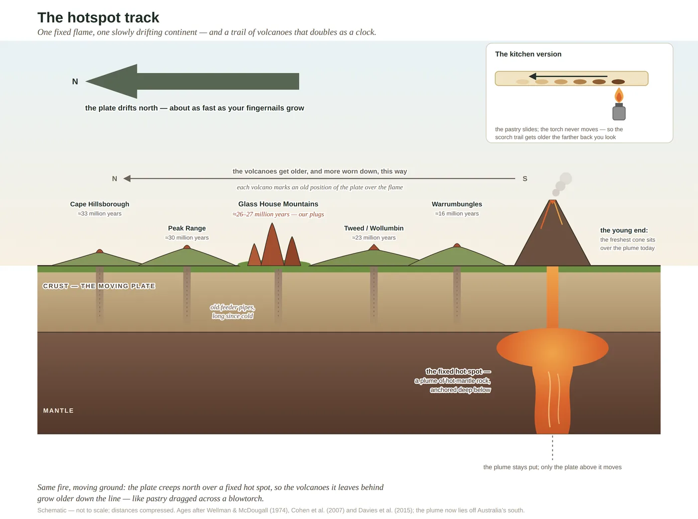
Why here? Because the ground is far less stationary than it feels. The continent drifts slowly north over a fixed hot spot deep in the mantle, and where the crust passes over that flame it melts and erupts, then moves on and cools, leaving a trail of dead volcanoes down eastern Australia like pastry dragged across a blowtorch. The Glass House peaks are one knot in that trail — one bead on the coastal line of it, not on the famous inland track that runs two thousand kilometres through the interior.
And then the fires went out, twenty-six million years ago, and the only force more patient than deep time took over: the weather. Every day since, rain and river have been quietly disassembling the country, erasing whole volcanoes and lowering the land by hundreds of metres, until only the hard hearts are left standing as the peaks we climb. So the most solid-looking things on the horizon are in fact temporary — leftovers, halfway through disappearing. Deep time laid out the ground. What happens to that ground next, as it crumbles into soil, is where the living world finally gets its foothold.
In depth — the mechanism
Deep time is the force that lays out the board every other force plays on. The coast is built of three raw materials of wildly different ages, and reading it begins with telling them apart. The plugs: silica-rich, viscous lava that cooled hard in the throats of Oligocene volcanoes and now stands exhumed as the Glass House Mountains, Mount Coolum, Mount Ninderry and their kin — the plugs dated to roughly 26–27 Ma (Cohen et al. 2007). The basalt: silica-poor, runny sheet lava that flooded flat and, under high rainfall and enough time, weathers to deep chocolate-red, nutrient-rich clay — the Blackall Range and Buderim, the richest soil the coast owns (Willmott 2007). The sand: the youngest ground of all, quartz swept north by longshore drift and heaped into dunes across the last few hundred thousand years, the oldest Cooloola dunes dated by single-grain OSL to ~700–800 ka (Ellerton et al. 2020).
Why the volcanoes lit here at all is the elegant part: the continent drifts slowly north over a fixed hot spot in the mantle, so the plate carries each patch of crust over the flame and away again, leaving an age-progressive trail of volcanoes down eastern Australia. The "longest continental hotspot track on Earth" superlative belongs to the inland Cosgrove track (~2,000 km, Davies et al. 2015); the Glass House plugs sit on the separate, more easterly coastal lineament — a related expression of the same northward march, not the Cosgrove track itself. Beneath both the fire-rocks and the sand lie two quieter, older layers: Mesozoic sandstones (the Landsborough Sandstone that floors much of the coastal lowland) and, older again, the folded Palaeozoic basement (>300 Ma). Four grounds, stacked in order of age, with an abyss of time between them.
The force is the time as much as the rock. The volcanoes fell silent some 26–27 million years ago, and every day since, rain and river have hauled the landscape off to the sea — whole cones erased, the surface lowered by hundreds of metres, the hard plugs left marooned as peaks. So the mountains are not permanent monuments but durable leftovers, halfway through vanishing; and the handover from rock to living world runs through weathering, the next force in line, which turns each of these raw materials into the soil that decides, via the gradient rule, what is allowed to grow.
Concepts this teaches — follow a thread
The gradient rule (substrate writes the country)Weathering — how rock becomes soil
Sources for this guide — followable
- Cohen, B.E. et al. (2007). ⁴⁰Ar/³⁹Ar constraints on the timing of Oligocene intraplate volcanism, SE Queensland (incl. the Glass House Mountains). Australian Journal of Earth Sciences 54(1): 105–125. (Glass House plugs ~26–27 Ma — verified; prefer 26–27 Ma over a loose "25–27 Ma".) — Glass House Mountains plugs dated ~26–27 Ma (⁴⁰Ar/³⁹Ar).
- Davies, D.R. et al. (2015). Lithospheric controls on magma composition along Earth's longest continental hotspot track. Nature 525: 511–514. (The Cosgrove track — source of the "longest track on Earth" superlative; the Glass House plugs sit on the separate easterly coastal lineament.) — The Cosgrove track (longest continental hotspot track); the Glass House plugs sit on the separate easterly coastal lineament.
- Willmott, W. (2007). Rocks and Landscapes of the Sunshine Coast (2nd ed.). Geological Society of Australia. (Local basement = Amamoor & Booloumba Beds; North Arm Volcanics; Landsborough Sandstone. NB: Neranleigh–Fernvale Beds are the Gold Coast/Brisbane equivalent, not the Sunshine Coast basement.) — Regional geology — plugs, basalt-to-red-clay, sandstone basement and coastal sand masses.
- Ellerton, D., Rittenour, T., Shulmeister, J. et al. (2020). An 800-kyr record of dune emplacement in relationship to high sea-level forcing, Cooloola Sand Mass. Geomorphology 354: 106999. (Oldest dunes ~700–800 ka, single-grain OSL.) — Oldest Cooloola dunes ~700–800 ka, single-grain OSL — the youngest of the four grounds.
Cited · traceable Last checked 2026-07. Deep-tier claims rest on, and were checked against, Cohen et al. 2007, Aust. J. Earth Sci. 54:105–125; Davies et al. 2015, Nature 525:511–514; Ellerton et al. 2020, Geomorphology 354:106999; Willmott 2007, Rocks and Landscapes of the Sunshine Coast (2nd ed.) — every source is listed below and followable. Grounded in Same Sky, Different Ground.