A place
Kondalilla Falls
A waterfall on the Blackall Range where a stream saws off the edge of the hard basalt cap — rainforest crowding the cool, shaded gorge below, drier open forest on the sunlit tops above.
- On the gradient
- Range crest and gorge — the wet, fertile top of the reef-to-range climb, cut by a waterfall
- Rock
- Maleny basalt capping older sedimentary bedrock (Blackall Range)
- Soil
- Deep red basalt soil on the range top (inferred from the Blackall Range basalt geology); thin skeletal soil on the exposed rock lip
- A waterfall dropping off a lip of hard, dark rock
- Lush, ferny rainforest in the shaded, damp gorge below the fall
- Drier, more open eucalypt forest on the sunlit rim above
- A high hinterland range that catches heavy rain
Kondalilla Falls is where a hinterland stream reaches the edge of the Blackall Range's basalt cap and drops off it in one long fall. The hard dark rock makes the lip; below it, in the cool, damp, shaded gorge, grows lush ferny rainforest, while the drier, sunnier tops above carry open eucalypt forest. Same hill, two forests — and the waterfall marks exactly where the ground changes.
Walk the track to Kondalilla and, before you ever see the water, the forest tells you where you are going. Up on the tops the country is open and sunny, eucalypts spaced over a grassy floor, the ground dry underfoot between rains. Then the path tips downward toward the sound of falling water, the trees close overhead, the light drops, the air cools and dampens, and by the time you reach the gorge you are standing in rainforest — ferns dripping, palms crowding the shade, the whole green room humming with damp. You have walked from one forest into another in a few hundred metres, and the thing that draws the line between them is the waterfall itself.
Here is why. The Blackall Range is a slab of hard basalt laid over softer rock beneath, and a stream running across the top eventually reaches the edge of that slab and drops off it. The dark basalt is tough and holds the lip; the softer rock below wears back faster; and the water is left to leap the step between the two. That is a waterfall in a single sentence — hard rock over soft, and gravity doing the rest. It is the same rule that stands the peaks up and lets the rivers wander, read here as a single bright ribbon falling off a rock edge.
And the two forests follow from the same geometry. The basalt tops are high and catch the heaviest rain, and they weather to the deep red soil that is the richest in the region — the wet, fertile end of the whole gradient. But it is the gorge that grows rainforest, because the gorge adds the one thing the tops lack: shelter. Down in the shaded cleft the forest stays cool, humid and still, too damp to burn, and that is exactly the refuge rainforest needs; up on the exposed rim, drier and open to sun and fire, the eucalypts hold the ground instead. Read the rock, read the water, and the living cover reads itself — with the fall marking the seam. A practical word in the book’s spirit: the rock at the lip and the pools below are slick, and the drop is real. The country rewards the reading; it does not forgive a careless step.
In depth — the mechanism
Kondalilla reads the gradient rule at the scale of a single gorge. The Blackall Range is capped by Maleny basalt sitting on older, softer sedimentary bedrock, and a waterfall is what you get where a stream cuts down to that boundary: the hard basalt resists and holds the edge, the softer rock beneath it erodes back, and the water is left to leap the step between them (Willmott 2007 — the region's hard-stands-soft-falls geology, read here as a caprock waterfall). Over the basalt the range also catches the heaviest rain and weathers to a deep red Ferrosol, so the top of this country is the wet, fertile end of the reef-to-range climb — exactly the ground rainforest wants (see basalt-fertility).
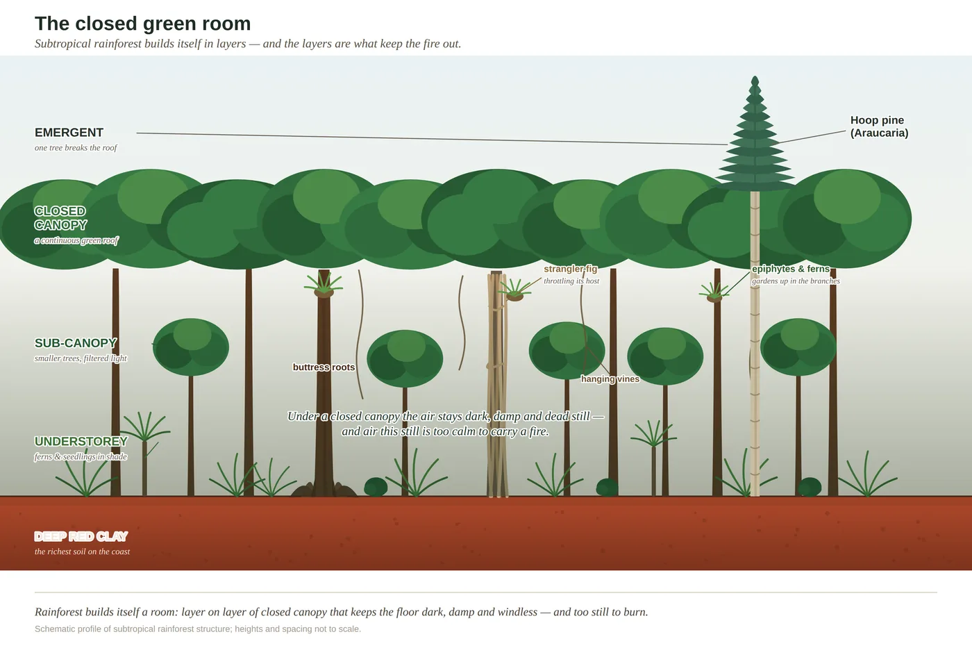
But height and rich rock are not the whole of it; shelter finishes the reading. Down in the shaded, humid, fire-protected gorge below the fall the forest closes into subtropical rainforest — the layered, ferny, closed-canopy structure of the SE Queensland uplands (see rainforest-structure; Leiper et al. 2022) — while the drier, sunnier, more exposed tops on the rim carry open eucalypt forest. That split is the gradient rule run on one hillside, the same pattern read on Mount Ninderry: dry exposed ground open, sheltered moist gullies wet.
Two honest calibrations, carried from the book's own Notes. (1) The rock at the lip is attributed from the Blackall Range's regional geology — a basalt cap over older sedimentary bedrock (Landsborough Sandstone / metasediments) — not from a survey of the fall itself; the caprock-waterfall reading is sound, but flagged as an inference. (2) The deep red basalt soil is likewise inferred from the range's geology rather than a site-specific soil survey. What is not in doubt is the lesson the place makes plain: read the rock and the water together and the two forests sort themselves out in front of you, the fall drawing the line between them.
Concepts this teaches — follow a thread
Basalt fertility (why red ground grows rainforest)Rainforest structure (the layered forest)The gradient rule (substrate writes the country)
Sources for this guide — followable
- Willmott, W. (2007). Rocks and Landscapes of the Sunshine Coast (2nd ed.). Geological Society of Australia. (Local basement = Amamoor & Booloumba Beds; North Arm Volcanics; Landsborough Sandstone. NB: Neranleigh–Fernvale Beds are the Gold Coast/Brisbane equivalent, not the Sunshine Coast basement.) — Blackall Range basalt cap over older sedimentary bedrock; differential erosion (hard rock holds the waterfall's lip) and deep red basalt soil — regional geology basis.
- Leiper, G. et al. (2022). Mangroves to Mountains (3rd ed.). Native Plants Queensland. — Subtropical rainforest structure and flora of the shaded hinterland gorges; open eucalypt forest of the drier tops.
Test yourself →
You're walking a hinterland range and the track drops toward the sound of falling water. A stream leaps off a lip of hard, dark rock into a shaded gorge. Down in the cool, damp cleft below the fall grows lush, ferny rainforest; up on the sunlit rim above, the forest is drier and more open. What country are you reading, and why do two different forests meet at the waterfall?
Cues: A waterfall dropping off a lip of hard, dark rock · Lush, ferny rainforest in the shaded, damp gorge below the fall · Drier, more open eucalypt forest on the sunlit rim above · A high hinterland range that catches heavy rain
Read the rock and the water together. A waterfall over a hard dark lip is a caprock fall: a stream reaches the edge of a resistant basalt cap sitting on softer rock, the hard rock holds the lip while the soft rock beneath erodes back, and the water leaps the step. On the Blackall Range that cap is basalt, which weathers to the region's richest red soil and sits where the rain is heaviest — the wet, fertile top of the gradient (basalt-fertility). But the two forests are sorted by shelter, not just soil: the shaded, humid, fire-protected gorge below the fall stays too damp to burn and grows rainforest, while the drier, sunnier, more exposed rim carries open eucalypt forest. That is the gradient rule run on one hillside, with the waterfall marking the seam. (Ch 5; Ch 13.)
Cited · traceable Last checked 2026-07. Deep-tier claims rest on, and were checked against, Willmott 2007, Rocks and Landscapes of the Sunshine Coast (2nd ed.) — Blackall Range basalt cap / caprock waterfall; Leiper et al. 2022, Mangroves to Mountains (3rd ed.); Ch 5 water & Ch 13 rainforest Notes (streams saw down through the basalt cap; gorge rainforest vs open tops; basalt soil inferred from regional geology, flagged — verified July 2026) — every source is listed below and followable. Grounded in Same Sky, Different Ground.