An ecosystem
Sea country
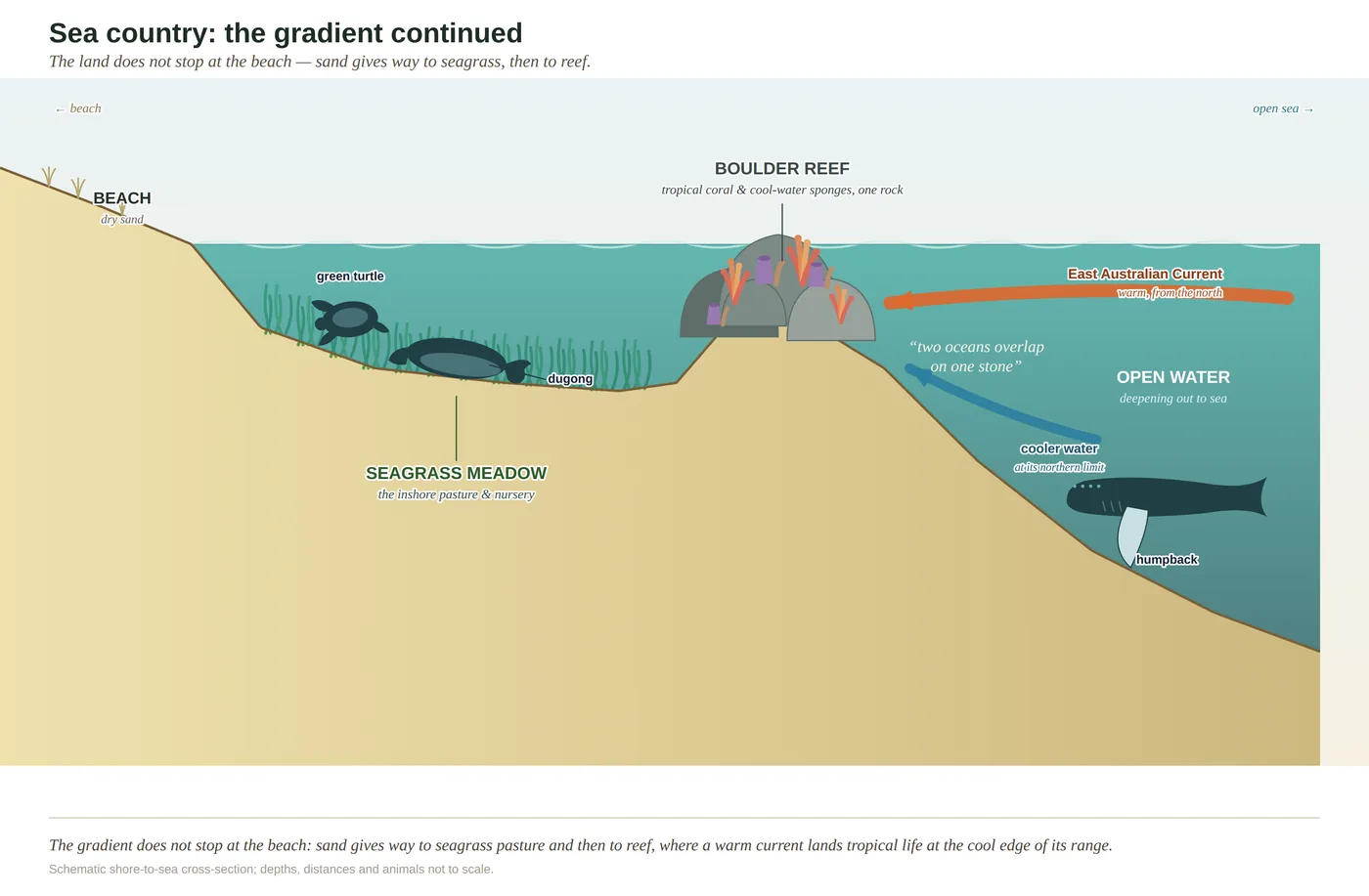
The land's gradient carries on underwater — beach to seagrass pasture to sand flat to headland reef — and out on the reef two oceans, warm and cool, share a single rock.
- On the gradient
- The marine pole of the gradient — beach through seagrass and sand flat to headland reef
- Rock
- Nearshore soft sediment (sand and mud) with volcanic/sedimentary headland reef
- Soil
- Marine sand and mud over rock; hard substrate on the headland reefs
- A rocky headland reef in clear water — hard bottom, not sand
- Tropical hard coral and cool-water sponges/seaweeds sharing one boulder
- Bright reef fish moving in pairs over the rock
- A whale spout offshore in winter
The coast does not stop at the beach. The same gradient you can read up on the range runs on under the water: surf beach, then pale-green seagrass meadow over sand, then open sand flats, then a boulder reef off the headland. And on that reef something rare happens — the warm current from the tropics lays coral against cool-water sponges on the one stone, so two oceans' worth of animals live side by side.
The Sunshine Coast does not end where the sand goes under the water. The soils and the slopes we spend the whole book reading simply change into something we cannot walk on, and so have learned to overlook. But the sea off this coast is a mosaic, as legible once you know how to read it as the gradient ashore — and it runs in the same order.
Think of the seabed near the shore as the land’s gradient continued, only flooded. Where the water is shallow, sheltered and clear, over soft sand, grow the seagrass meadows: a flowering plant, not a weed, carpeting the shallows, feeding the things that graze it, hiding a whole generation of young fish and prawns among its blades, and holding the sediment steady. It is the underwater equivalent of the wetland — humble, easily overlooked, easily wrecked by anything that clouds the water and shades it out, and worth far more than it looks. Further out, where the bottom turns hard around the headlands, a completely different community of seaweeds, sponges, corals and reef fish claims the rock.
And it is on that rock that the coast does something rare. A warm current, the East Australian Current, runs down the Queensland coast carrying tropical water and the drifting young of tropical animals spawned far to the north. Many of them settle here, at the very southern edge of where warm-water species can survive, while cool-water species from the temperate south reach their northern edge close by. So on a single boulder off a headland you can find hard coral, unmistakably tropical, growing within a fin’s-length of the leathery seaweeds and sponges of the cool south — two oceans, warm and cool, sharing one stone, and the reef all the richer for the improbability.
Read the sea as country, then, not as scenery. The pale-green shallows over sand are seagrass, the pasture and nursery of the inshore sea. The boulder reef off the headland, coral and cool-water sponge on the same rock, is the warm current’s handiwork and a gauge of how fast the sea is changing. With the sea, the gradient is complete: read from the range to the reef and back again, every world in its place, each one legible from the ground — or the seabed — it stands on.
In depth — the mechanism
Sea country is the gradient rule carried out past the tideline, sorted now by depth, light, wave energy and the nature of the bottom rather than by soil. Where the rivers and tides drop fine sediment in the sheltered bays and passages, the bottom is soft, and wherever the water stays shallow and clear enough for light to reach it grows seagrass — true flowering plants, not weed, carpeting the shallows (see seagrass-meadows). That meadow is the inshore pasture, nursery and sediment-trap all at once: it feeds the dugong and the green turtle, shelters a whole generation of juvenile fish and prawns among its blades, holds the sediment steady, and locks carbon into the mud beneath it. Lose it and you do not lose one plant; you pull the floor out from under the inshore food web.
Out past the seagrass and the open sand, where the bottom turns hard around the rocky headlands and offshore reefs, a wholly different community takes hold — seaweeds, sponges, soft corals, urchins and reef fish clinging to the stone. These reefs sit at one of the more interesting addresses in Australian marine biology, because this is where two oceans overlap (see two-oceans-overlap). The East Australian Current runs warm tropical water down the Queensland coast, carrying the drifting larvae of tropical fish and corals spawned far to the north; many settle here, at or near the southern limit of where warm-water species can live, while cooler-water species from the temperate south reach their northern limit not far away. On one boulder, tropical hard coral grows within a fin's-length of the leathery brown seaweeds and sponges of the cool south — a community that has no business existing in one place, assembled by the current out of two seas.
Two honest calibrations carried from the book. (1) The temperate element on these reefs is mainly sponges and seaweeds, not the dense kelp forest of cooler NSW waters — kelp is marginal this far north. (2) The blue-carbon value of the seagrass is well established in kind but kept qualitative: specific per-hectare figures for these particular meadows are not settled enough to quote. What is not in doubt is that this overlap makes the reef a sensitive gauge of a warming sea: a community living at the edge of its members' tolerances feels every shift in the water, and marine heatwaves reaching down the current are already nudging the boundary south.
Concepts this teaches — follow a thread
Seagrass meadows (the inshore pasture and nursery)Two oceans on one rock (the tropical–temperate overlap)The gradient rule (substrate writes the country)
Sources for this guide — followable
- McPhee, D. (2017). Environmental History and Ecology of Moreton Bay. CSIRO Publishing. — Inshore marine habitats, seagrass ecology (nursery, grazing, sediment) and reef communities of the bay region.
- Davie, P. (1998). Wild Guide to Moreton Bay. Queensland Museum. — Regional marine natural history — seagrass, reef fauna and the EAC-driven fauna of Moreton Bay.
- Dugong: Moreton Bay supports a nationally significant, strongly seasonal population — Lanyon's 1995 bi-monthly aerial surveys ranged from ~503 (July) to ~1,019 (January) (Wildlife Research). Correction: earlier drafts attributed this to "Lawler/Marsh ~600–800"; the Moreton Bay survey authority is Janet Lanyon (Lawler/Marsh lead northern/GBR dugong work). Cite the seasonal range or "several hundred to ~1,000," not a fixed 600–800. — Dugong dependence on the inshore seagrass meadows (Moreton Bay aerial surveys).
Test yourself →
You duck under with a mask off a rocky headland in clear water. On a single boulder, tropical hard coral is growing within a fin's-length of leathery cool-water sponges and seaweeds; butterflyfish move past in pairs; and out beyond the break, in winter, a whale spouts. What country are you reading, and what put this improbable mix on one rock?
Cues: A rocky headland reef in clear water — hard bottom, not sand · Tropical hard coral and cool-water sponges/seaweeds sharing one boulder · Bright reef fish moving in pairs over the rock · A whale spout offshore in winter
The tell is the mix on one rock. Hard bottom off a headland is reef, not seagrass (which grows on sheltered sand), and tropical coral sitting right beside cool-water sponges and seaweeds is the signature of the two-oceans overlap. The East Australian Current carries warm water and tropical larvae down the coast to the very southern edge of where they can live, while temperate species reach their northern edge close by — so both share the reef, each near its limit. It is not a Great Barrier-scale coral reef (the water is not uniformly warm; corals are present but do not build the tropical framework), and it is not a kelp forest (kelp is marginal this far north — the temperate element here is sponges and seaweeds). The winter whale spout is the humpback migration passing offshore. (Ch 14.)
On the headland reefs of the Sunshine Coast, tropical species (corals, reef fish) live on the same rock as temperate species (sponges, seaweeds, cool-water fish). What best explains why both faunas share this one stretch of coast?
This coast is a biogeographic overlap, and the current is what makes it one. The East Australian Current runs warm tropical water and the drifting larvae of tropical fish and corals down the Queensland coast; many settle here, at or near the southern limit of where warm-water species can live. Cool-water species from the temperate south reach their northern limit close by. So the two faunas meet and mingle on the same reef, each near the edge of its tolerance — which also makes the community a sensitive gauge of a warming sea. It is not a uniformly tropical outpost of the Great Barrier Reef (the water is not that warm, and corals here do not build the tropical framework), the species are not shipping introductions, and they are genuinely different animals, not one changing with the season. (Ch 14.)
Cited · traceable Last checked 2026-07. Deep-tier claims rest on, and were checked against, McPhee 2017, Environmental History and Ecology of Moreton Bay; Davie 1998, Wild Guide to Moreton Bay; Lanyon 1995 dugong surveys (Wildlife Research); Ch 14 sea-country Notes (EAC tropical–temperate overlap, seagrass, blue carbon kept qualitative — verified July 2026) — every source is listed below and followable. Grounded in Same Sky, Different Ground.