A place
The Conondale Range
The high, wet inland ranges behind the coast — tall wet sclerophyll and rainforest on the highest-rainfall country, gorge streams and giant trees: the tallest, wettest pole of the forest gradient.
- On the gradient
- High-rainfall inland ranges — the wettest, tallest pole of the forest gradient
- Rock
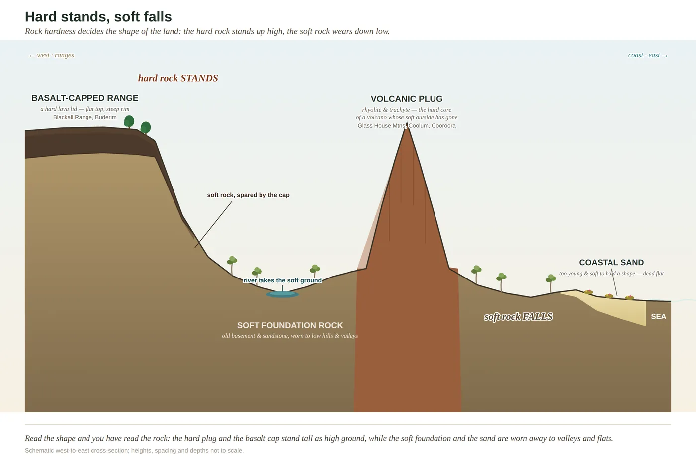
- Metasedimentary basement (Amamoor & Booloumba Beds) with basalt and volcanic caps on the higher ground
- Soil
- Deeper, moister forest soils; deep red basalt soil where basalt caps occur (inferred from regional geology)
- Regional ecosystem
- 12.11.1
The Conondale Range is the high, wet inland country behind the Sunshine Coast — ranges that catch the heaviest rain and grow the tallest forest. Here the gum forest rises into towering wet sclerophyll, with straight trunks lifting many metres before they branch, and rainforest fills the sheltered gullies and gorges. It is the wettest, tallest end of the whole forest gradient, and one of the last strongholds of the biggest trees on the coast.
Keep climbing inland from the coast, past the first ranges, and the country goes on rising and getting wetter until you reach the Conondale — the high, folded, rain-soaked range that stands at the far end of the whole reef-to-range climb. This is where the forest stops being scenery and starts being cathedral. The gum trees here are not the spaced, sunlit trees of the open ridges; they are giants, straight pale columns lifting clear for many metres before they throw a branch, standing over a soft green understorey that already looks half like rainforest. This is the tall timber, the wet sclerophyll, and it grows this big for one simple reason: this is the wettest country on the coast, and water, on good ground, builds trees.
The strange thing about the tall forest is that it is never quite settled. Its giant eucalypts cannot raise their own young in their own shade, so the forest depends on fire to come through now and then, open the ground, and beat back the rainforest that is forever creeping up out of the sheltered gullies. Withhold fire and the gullies win — the rainforest closes over and the tall gums, unable to regenerate, are slowly replaced. Send too much fire, too fierce, and the slow growers and the damp-loving gully plants are killed outright. So the grandest forest on the coast lives balanced on a knife-edge of flame: too little and it turns into something else, too much and it burns down to something poorer. It is one of the quiet marvels of this country that its most majestic forest stands only by the grace of a force we usually think of as destruction.
Drop into one of the gorges — Booloumba country, where streams saw through the range — and you leave the eucalypts behind entirely and step into cool, closed rainforest, the wet pole of the gradient at its purest. This is deep, sheltered, ancient forest, and it holds animals that reach no further: turn a rotting log here and you may find a land mullet, a big glossy blue-black skink as long as your forearm, running out of continent, because the Conondale is about as far north as it gets. Honesty about the rock, though: much of this range is not the rich red basalt of Maleny but old, hard metasedimentary stone, so the wealth here is written less in the rock than in the rain and the shelter. It is the most water and the deepest gullies, more than any one soil, that grow the biggest trees on the coast.
In depth — the mechanism
The Conondale Range is the wet, tall pole of the forest gradient — the country you reach at the far, high, inland end of the reef-to-range climb, where the rain is heaviest and the forest is grandest. On the better, moister soils and lower slopes grows wet sclerophyll forest: tall, open eucalypt forest whose straight trunks spear clear for many metres over a soft-leaved, almost rainforest-like understorey (Leiper et al. 2022). These are still sclerophyll trees — hard-leaved eucalypts, the same tribe as the wallum's — but given enough water and shelter they grow to the tallest timber on the coast. In the wettest, most fire-protected gullies and gorges, rainforest closes over the top of them altogether.
What holds the two apart is fire (see the-fire-boundary). Tall wet sclerophyll is a forest caught between two fates: its giant eucalypts cannot reproduce in their own shade, so without occasional fire to open the ground and hold back the rainforest creeping up the gullies, the tall forest slowly gives way to rainforest — while too much fire, or too fierce, kills the slow growers and the fire-sensitive gully species outright. Some of the most majestic forest on the coast stands only at the sufferance of flame, poised on that boundary. A signature of how far this wet country reaches: the land mullet, a glossy blue-black rainforest skink the length of your forearm, runs out of continent here — the Conondale Range is about its northern limit (Ch 16 Notes).
An honest calibration on the rock. Much of the Conondale is built not of basalt but of old metasedimentary basement — the Amamoor and Booloumba Beds (Willmott 2007) — so basalt-fertility applies to the basalt caps and richer pockets on the higher ground, not to the whole range; the dominant driver of the tall wet forest here is the highest rainfall and the shelter of the gorges as much as the rock. Where basalt does cap the range, it adds the deep red fertile soil rainforest most wants; elsewhere the forest rides on deeper, moister soils gathered in sheltered ground. Read the range as the wet extreme of the gradient, and the giant trees and the gorge rainforest as what the most rain and the deepest shelter, more than any one rock, will grow.
Concepts this teaches — follow a thread
Basalt fertility (why red ground grows rainforest)The fire boundary (how flame draws the line)Sclerophylly (the tough-leaf economy)
Sources for this guide — followable
- Willmott, W. (2007). Rocks and Landscapes of the Sunshine Coast (2nd ed.). Geological Society of Australia. (Local basement = Amamoor & Booloumba Beds; North Arm Volcanics; Landsborough Sandstone. NB: Neranleigh–Fernvale Beds are the Gold Coast/Brisbane equivalent, not the Sunshine Coast basement.) — Conondale basement = Amamoor & Booloumba Beds (metasediments); basalt/volcanic caps on the higher ground — regional geology basis for the honest rock calibration.
- Leiper, G. et al. (2022). Mangroves to Mountains (3rd ed.). Native Plants Queensland. — Tall wet sclerophyll forest and subtropical rainforest of the high inland ranges — structure and flora.
Cited · traceable Last checked 2026-07. Deep-tier claims rest on, and were checked against, Willmott 2007, Rocks and Landscapes of the Sunshine Coast (2nd ed.) — Amamoor & Booloumba Beds, Conondale basement; Leiper et al. 2022, Mangroves to Mountains (3rd ed.); Ch 11 wet-sclerophyll & fire-boundary Notes; Ch 13/Ch 16 Notes (land mullet Bellatorias major, Conondale = northern limit) — verified July 2026 — every source is listed below and followable. Grounded in Same Sky, Different Ground.