A place
The Glass House Mountains
A cluster of sheer volcanic plugs rearing straight off the plain — the frozen plumbing of vanished volcanoes, now carrying eucalypt forest and montane heath on bare rock, with rainforest hiding in the gullies.
- On the gradient
- Volcanic plug — hard-rock peaks off the lowland; dry eucalypt forest and montane heath on rock, rainforest in the gullies
- Rock
- Rhyolite/trachyte volcanic plugs (~26–27 Ma) — the eroded cores of hotspot-track volcanoes
- Soil
- Thin, skeletal soil on bare rhyolite/trachyte; deeper, moister soil pooled in the gullies
- Open, spaced canopy you can see a long way through
- Hard, grey-green leaves that hang vertically
- Deep-furrowed near-black (ironbark) or fibrous reddish bark
- A grassy, sometimes flowering understorey rather than a shrubby or dim one
- Old fire-scars (black 'cat-faces') at the base of trunks
Those blue peaks that float on the inland horizon are not really mountains — they are the hard cores of old volcanoes, left standing after everything softer around them wore away. The rock is so hard and hungry that the whole gradient stacks up on a single hill: open gum forest on the slopes, a low heath clinging to the bare stone up top, and a pocket of rainforest tucked into the damp gully.
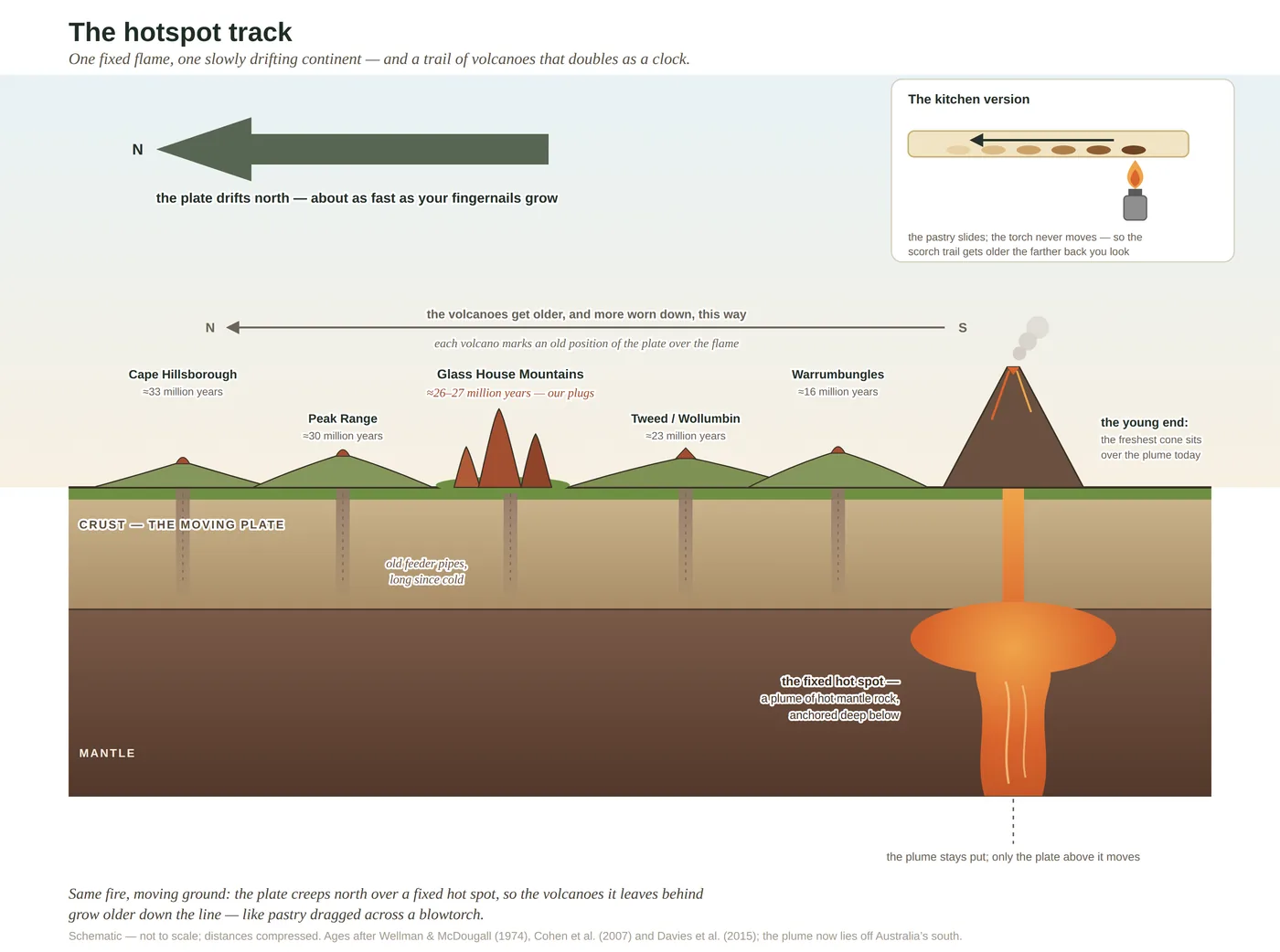
On a still morning the Glass House Mountains float blue and serene on the inland horizon, and nothing about the scene suggests violence. Those calm blue peaks are the cooled stumps of volcanoes. Around twenty-six or twenty-seven million years ago this stretch of coast sat over a furnace and burned, and what you see now is the wreckage, whittled by an almost unimaginable span of erosion into the shapes on the skyline. When you look at the peaks you are not looking at the volcanoes at all. You are looking at their frozen plumbing — the hard cores laid bare long after the volcanoes themselves rotted away.
The trick is that thick, silica-rich lava is too stiff to flow. It clogged the throats of the old volcanoes and set there as rhyolite and trachyte, some of the hardest, least-fractured rock in the region. When the softer country all around was stripped back by hundreds of metres and carried out to sea, those hard plugs simply refused to rot, and were left standing sheer and improbable off the flat plain. Give erosion a few more million years and even these will follow the volcanoes that made them.
The reward for the walker is that hard rock makes hungry country, and hungry country lays the whole gradient out on a single hill. Climb one of these peaks and you pass, in an afternoon, from open eucalypt forest on the thin, dry soil of the slopes, up through a low montane heath of hardy plants clinging to bare stone, while a pocket of rainforest waits in the damp of the gully below. Substrate and water, not rainfall, decide it, exactly as they do across the coast at large — the Glass House Mountains just draw the lesson steep and clear.
And because so much of it is fire-shaped forest and heath, it answers to the same conversation as the rest of the country: not one right fire, but a patchwork of intervals, frequent on the heath, rare in the gully, that keeps the fire-hungry and the fire-shy in the same landscape. Read the shape first — a sheer, lonely, sharp-summited peak is a volcanic plug every time — and the rest of the hill reads itself.
In depth — the mechanism
The Glass House Mountains are the region's signature landform and the clearest lesson in how it was made. Around 26–27 million years ago this was volcanic country, part of a long age-progressive hotspot track laid down as the Australian plate drifted north over a fixed plume of hot mantle (Cohen et al. 2007; the track logic worked out most fully for the inland Cosgrove lineament, Davies et al. 2015 — the Glass House plugs sit on the separate, more easterly coastal expression). The peaks are not the volcanoes; they are what solidified inside them. Silica-rich lava is stiff, barely able to flow, so it cooled in the throats and necks as hard, dense rhyolite and trachyte. When the softer cones and ash rotted and washed away over the following tens of millions of years — the land surface lowered by hundreds of metres — those hard plugs were left marooned, "exhumed" rather than uplifted (Willmott 2007). Tibrogargan and Beerwah stand tall today only because everything that once stood as tall beside them, but softer, has gone; the tall trachyte columns of Beerwah's Organ Pipes are cooling-contraction joints, cracks the rock made shrinking on its own first day.
That hard, unbroken rock makes hard, hungry country, and the result is a whole gradient compressed onto one hill. Thin, skeletal soil on the exposed rhyolite carries dry, open eucalypt forest and, on the barest stone near the tops, a low montane heath of tough, specialised plants gripping the rock. Where soil gathers and the damp collects in the gullies, rainforest gets a foothold. So the same plug shows the reef-to-range logic in miniature: substrate and water, not rainfall, decide what grows where. And because so much of it is fire-shaped gum forest and heath, it lives by the same rule as the rest of the coast — there is no single right fire for it, only a patchwork of intervals suited to each face of the hill, the mosaic that keeps both the fire-hungry heath and the fire-shy gully in the same landscape.
A note on the name, kept to the public record: James Cook, sailing past on 17 May 1770, thought the abrupt peaks resembled the glass furnaces — the "glass houses" — of his day, and set the name on his chart. The peaks had, of course, been named and known for many thousands of years before that, and carry Kabi Kabi names and meanings that are not this book's to relate.
Concepts this teaches — follow a thread
Sources for this guide — followable
- Cohen, B.E. et al. (2007). ⁴⁰Ar/³⁹Ar constraints on the timing of Oligocene intraplate volcanism, SE Queensland (incl. the Glass House Mountains). Australian Journal of Earth Sciences 54(1): 105–125. (Glass House plugs ~26–27 Ma — verified; prefer 26–27 Ma over a loose "25–27 Ma".) — Glass House plugs ~26–27 Ma; intraplate hotspot volcanism, SE Queensland.
- Davies, D.R. et al. (2015). Lithospheric controls on magma composition along Earth's longest continental hotspot track. Nature 525: 511–514. (The Cosgrove track — source of the "longest track on Earth" superlative; the Glass House plugs sit on the separate easterly coastal lineament.) — Age-progressive hotspot-track mechanism (Cosgrove track superlative; Glass House on the separate coastal lineament).
- Willmott, W. (2007). Rocks and Landscapes of the Sunshine Coast (2nd ed.). Geological Society of Australia. (Local basement = Amamoor & Booloumba Beds; North Arm Volcanics; Landsborough Sandstone. NB: Neranleigh–Fernvale Beds are the Gold Coast/Brisbane equivalent, not the Sunshine Coast basement.) — Volcanic-neck plugs, differential erosion, rhyolite/trachyte, and the montane-heath-on-rock landform.
- Leiper, G. et al. (2022). Mangroves to Mountains (3rd ed.). Native Plants Queensland. — Regional flora authority for the montane-heath and eucalypt-forest plant communities on the plugs.
- Dooley, M., Lewis, T. & Schmidt, S. (2023). Fire frequency has a contrasting effect on vegetation and topsoil in subcoastal heathland, woodland and forest ecosystems, south-east Queensland. Austral Ecology 48(8). (Long-term Peachester burning experiment; regular fire maintains understorey diversity, with a topsoil-carbon cost. First author Madeline Dooley — initial confirmed "M." against the paper, July 2026.) — Fire-frequency effects underpinning the mosaic across the plug's forest and heath faces.
Test yourself →
You're standing in open, sunny forest: the trees are well spaced with a grassy floor you can see a long way through, the leaves overhead are hard and grey-green and hang down, one trunk wears deep-furrowed near-black bark and another a fibrous reddish coat, and here and there a trunk carries a healed black scar at its base. What country are you reading — and what has shaped it?
Cues: Open, spaced canopy you can see a long way through · Hard, grey-green leaves that hang vertically · Deep-furrowed near-black (ironbark) or fibrous reddish bark · A grassy, sometimes flowering understorey rather than a shrubby or dim one · Old fire-scars (black 'cat-faces') at the base of trunks
Every cue points the same way. Hard, hanging grey-green leaves are the sclerophyll leaf — the tough, long-lived, well-defended leaf that scarce phosphorus forces on this flora, so the ground beneath is poor. The thick, furrowed ironbark and fibrous barks are fire armour: dead insulating coats that let the living tissue ride out a grass fire. And the open, grassy floor plus the healed fire-scars are the signature of regular cool burning — take the fire away and this floor thickens over with woody scrub and loses its diversity. Poor soil plus recurrent fire equals open gum forest. (Ch 4; Ch 6; Ch 11.)
A land manager decides to simplify: burn the whole reserve on exactly the same short interval, at the same intensity, everywhere, every time. Predict what this too-uniform fire regime does to the diversity of the country — and why.
The coast is a gradient, not one place, and each world along it wants a different flame: the rainforest none, the wet forest a little, the dry woodland a cool burn every few years, the wallum a burn often enough to crack its seed. Fire also sorts a landscape into a mosaic of ages — burnt beside long-unburnt — and diversity rides on having all those stages at once. Impose one interval and one intensity everywhere and you erase the mosaic: the country settles onto a single point of the cycle, and every species adapted to a different frequency, intensity or patch-age is squeezed out. The long-term Peachester experiment shows fire frequency working as exactly this master switch, and there is no single setting that suits everything. (Ch 6; Ch 11.)
Cited · traceable Last checked 2026-07. Deep-tier claims rest on, and were checked against, Cohen et al. 2007, Aust. J. Earth Sci. 54(1):105–125; Davies et al. 2015, Nature 525:511–514; Willmott 2007, Rocks and Landscapes of the Sunshine Coast; Cook's Endeavour journal, 17 May 1770; Kabi Kabi names acknowledged, not retold (cultural protocol) — every source is listed below and followable. Grounded in Same Sky, Different Ground.