A place
The Maroochy River flats
The tidal, brackish floodplain where the Maroochy spreads out to meet the sea — grey estuarine mud and river silt only just above the tide, with a buried acid hazard beneath and a large restoration letting the water back in.
- On the gradient
- Tidal floodplain — the bottom of the gradient, where the Maroochy meets the sea
- Rock
- Holocene estuarine mud and river alluvium
- Soil
- Estuarine mud and silt over buried sulfidic (acid-sulfate) sediment; tidal, brackish
- Soft grey mud, sulphurous underfoot, not firm ground
- Thousands of slender pencil-thin roots standing upright out of the mud
- A tide line marking how far the salt water climbs
- Behind the trees, an open salt-crusted flat of low succulents
The Maroochy River floodplain is flat, tidal, brackish ground — grey estuarine mud and river-laid silt lying only just above the reach of the sea. Much of it was drained for sugarcane a century ago, and much of it is now being deliberately re-wetted under the Blue Heart project, which lets both fresh and tidal water back onto land that was drained generations ago. Beneath the paddocks lies a catch: acid-sulfate soils, harmless while wet, that turn the creeks to acid if you drain them.
Come out onto the Maroochy on a falling tide, where a boardwalk carries you from the riverbank out over the mud, and the estuary hides nothing. This is the very bottom of the coast’s great slope: the flat, tidal, brackish ground the Maroochy River spreads across as it loses the last of its fall and meets the sea. It looks, to the casual eye, like a few hundred metres of grey wasteland. It is one of the busiest food factories on the coast.
Read it band by band and the estuary’s logic snaps into focus — seagrass in the channel, the grey-mangrove forest breathing through a thousand snorkel roots across the intertidal mud, the sun-baked saltmarsh on the higher flats behind. But the Maroochy carries a second lesson that the prettier reaches do not, and it is buried under your feet. Thousands of years of airless mud stored up a load of iron sulfides here, harmless while drowned; and for a century we drained this floodplain for cane without knowing that draining it wakes the hazard. Let the air into that mud and it makes sulfuric acid, and the next big rain flushes it into the creeks as a fish-killing slug — the “red-spot” ulcers on Bli Bli bream and flathead are its fingerprint.
The turn, when it came, was almost a parable. Once anyone bothered to price what this ground does for nothing — storing floods, filtering water, feeding the fishery, banking carbon, keeping the acid asleep — the case for rebuilding it became overwhelming. So the Blue Heart is letting the water back across the Maroochy floodplain, and at Yandina Creek the old cane paddocks turned themselves back into a wetland the moment the tide crept in through failed floodgates. The flats we spent a century draining are, slowly, being read again for what they always were.
In depth — the mechanism
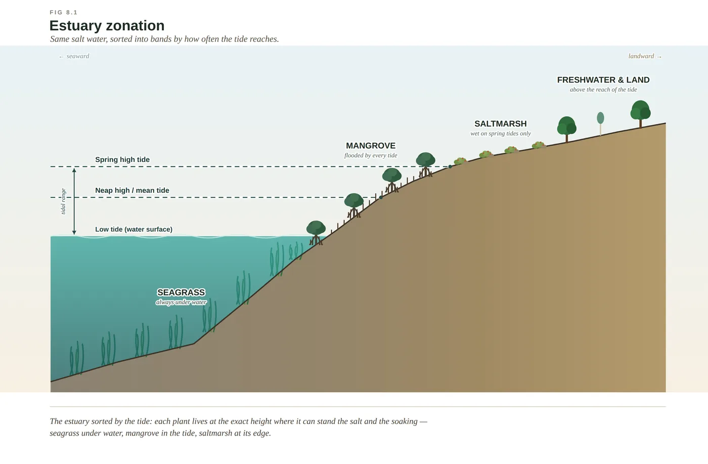
The Maroochy flats are the bottom of the coast's gradient — the tidal mud the whole reef-to-range slope drains into. Read the flat from the river bank inland and it sorts itself into the estuary's bands: seagrass in the channel shallows, a broad grey-mangrove forest breathing through its pneumatophores across the intertidal mud, and behind it the sun-baked saltmarsh of samphires and glassworts on the flats the spring tides reach only now and then (see estuarine-zonation). The Maroochy Wetlands Sanctuary boardwalk at Bli Bli runs you out over exactly this sequence without sinking you to the knees.
What makes the Maroochy a cautionary place is what lies under the mud (see acid-sulfate-soils). Thousands of years of waterlogged, airless sediment built up a store of iron sulfides that stay inert as long as they stay drowned. Drain the floodplain — dig a channel, drop the water table, let the air in — and those sulfides oxidise to sulfuric acid, which the next heavy rain flushes into the waterways in a slug carrying dissolved iron and aluminium, stripping the oxygen from the water and the protective slime from a fish's skin. The outbreaks of "red-spot" ulcers that turn up on bream and flathead around Bli Bli tend to follow these acid pulses.
An honest calibration. The acid is the trigger and aggravator, not the whole cause: red-spot (epizootic ulcerative syndrome) is driven by a waterborne mould, and the acid pulse is what stresses the fish enough to let it take hold. The remedy is the same insight run backwards — keep the sulfides drowned. That is a large part of what the Blue Heart is doing across the Maroochy floodplain: a partnership of Sunshine Coast Council, the Queensland Government, Unitywater and the Kabi Kabi, re-wetting drained land for flood storage, wetland habitat and carbon, and keeping the buried hazard safely asleep. The nearby Yandina Creek Wetland — old cane paddocks that quietly turned back into a bird-thick wetland when their tidal floodgates failed — is the proof that this ground will often rebuild itself the moment the water is let back.
Concepts this teaches — follow a thread
Estuarine zonation (the tide sorts the bands)Acid-sulfate soils (the buried acid)
Sources for this guide — followable
- Leiper, G. et al. (2022). Mangroves to Mountains (3rd ed.). Native Plants Queensland. — Mangrove, saltmarsh and reed/sedge flora of the floodplain (Mangroves to Mountains).
- McPhee, D. (2017). Environmental History and Ecology of Moreton Bay. CSIRO Publishing. — Estuarine fisheries nursery role and water-quality threats in the bay region.
- Davie, P. (1998). Wild Guide to Moreton Bay. Queensland Museum. — Regional estuarine fauna of the mangrove flats (Wild Guide to Moreton Bay).
Test yourself →
At low tide you walk out onto a wide flat of soft grey mud. Slender pencil-thin roots stand up out of the mud in their thousands around a band of low dark trees; behind them, on higher ground the water only sometimes reaches, is an open flat of low succulents with a faint white salt crust, and a clear tide line marks how far the water climbs. What country are you reading — and why does it look like this?
Cues: Soft grey mud, sulphurous underfoot, not firm ground · Thousands of slender pencil-thin roots standing upright out of the mud · A tide line marking how far the salt water climbs · Behind the trees, an open salt-crusted flat of low succulents
Every cue points to salt and tide. The grey, airless, sulphurous mud and the tide line say you are in the intertidal zone; the thousands of upright pencil roots are pneumatophores — mangrove snorkels that pipe air down to roots drowned in oxygen-starved mud. The salt-crusted succulent flat behind, on ground the tide reaches only occasionally, is saltmarsh. The two bands are sorted by how often the salt water reaches, the estuary's version of the gradient rule. (Ch 8.)
In an estuary, seagrass grows below the tide, mangrove in the tidal band that floods and drains twice a day, and saltmarsh on the higher flats the tide reaches only occasionally — always in that order. What sets the order of the bands?
Estuarine zonation is the gradient rule driven by the tide. The controlling variable is how often the salt water reaches — hydroperiod — running together with salinity and how airless the mud is. Seagrass takes the always-drowned ground, mangrove the twice-daily tidal band, saltmarsh the rarely-flooded flats; each plant holds the one height where it can just stand the conditions and would drown a step seaward or be outcompeted a step landward. It is not richness or height that sorts them, but tolerance. (Ch 8.)
Cited · traceable Last checked 2026-07. Deep-tier claims rest on, and were checked against, Ch 8 & Ch 10 (Maroochy Wetlands Sanctuary boardwalk; acid-sulfate soils / red-spot; Blue Heart & Yandina Creek), verified July 2026; McPhee 2017; Leiper et al. 2022 — every source is listed below and followable. Grounded in Same Sky, Different Ground.