A place
Mount Ninderry
An isolated hinterland peak standing off the coastal lowland — a hard volcanic stump that refused to wear down, carrying open eucalypt forest and bare rocky-outcrop scrub on thin, stony soil.
- On the gradient
- Isolated hinterland peak standing above the coastal lowland
- Rock
- Silicic volcanic rock — rhyolite/trachyte (North Arm Volcanics)
- Soil
- Shallow stony lithosol on hard silicic rock (inferred from rock type and steep exposed slopes)
- Regional ecosystem
- 12.12.15
- A steep, isolated peak standing well above a flat plain
- Bare rock at the top — a rounded dome or a cliff face
- Thin, stony soil, barely more than grit in the joints of the rock
- Low, wind-pruned heath and hard, grey-leaved open forest
Mount Ninderry is a lone peak above the flat country near Yandina — the hard, unbroken core of an old volcano left standing while everything softer around it wore away. It stands high, but its soil is thin and stony, so it grows tough open forest and rock-outcrop scrub, not the rainforest you might expect on a hilltop.
Pull off near Yandina and look up at Mount Ninderry, and you are looking at a survivor. It stands alone above the flat lowland like a piece that got left on the board after the game was cleared away — a steep, rocky peak with bare stone showing through the scrub near the top, and nothing else nearby its equal. It looks, reasonably enough, as though something shoved it up out of the plain. Nothing did. Ninderry is the hard, unbroken heart of an old volcano, and the only reason it stands high is that everything around it, being softer, has quietly gone. The plain was lowered by hundreds of metres over millions of years; the tough silicic rock of the plug simply refused to rot, and was left holding the sky.
Now here is where the peak teaches you something worth carrying to every hill you ever look at. On the great slope of this coast, height means wealth: the high basalt range at the top is the wet, deep-soiled, rainforest end of the country. So you climb Ninderry half-expecting a green, dripping summit — and get the opposite. Hard silicic rock weathers grudgingly, and gives up only a thin, stony, quick-draining soil with almost nothing in it. That is a recipe not for rainforest but for tough, open eucalypt forest and, on the bare rock pavements near the top, a low, wind-scoured scrub that roots in the cracks and hangs on out of obstinacy. The leaves are hard and grey — the sclerophyll leaf, a soil report you can read at a glance — because the ground is poor. Height, it turns out, does not buy you a rainforest. Soil and shelter do, and this peak has neither to spare.
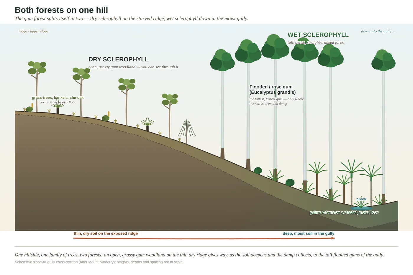
Walk it and you can watch the country’s one great rule run in miniature, right here on a single hill. The dry, exposed, sun-blasted faces — where the thin soil bakes and drains in an afternoon — carry the open forest. Slip into a sheltered gully on the shaded side, where soil gathers deeper and the damp lingers, and the forest closes over, greens up, and begins to lean toward rainforest. Same hill, same rain, two different worlds — and the difference is written entirely in where the soil is deep and the water stays. That is the whole book in one climb: read the rock, read the soil, and the living cover reads itself.
In depth — the mechanism
Ninderry is a small, sharp lesson in the region's master rule — hard stands, soft falls. It is an exhumed volcanic mass of silicic rock (rhyolite/ trachyte of the North Arm Volcanics), dense and poorly jointed enough to have resisted weathering while hundreds of metres of softer foundation rock were stripped off the plain around it (Willmott 2007). The peak was never pushed up; the land beside it was lowered, and the hard core was left marooned as high ground — the same story as the Glass House peaks and Mount Coolum.
What matters ecologically is that height here buys you the opposite of what a newcomer expects. On the reef-to-range gradient the high ground (the basalt range) is the wet, rich, rainforest end — but a lone plug is high and poor. The silicic rock weathers slowly and yields only a shallow, stony, fast-draining soil (a lithosol, inferred here from the hard rock and steep exposed slopes, not a site soil survey), so the exposed slopes and rocky pavements carry open eucalypt forest and low, wind-pruned rocky-outcrop shrubland — the sclerophyll economy of thin ground — rather than closed forest. The gradient rule then runs again at the scale of this one hill: the dry, fast-draining exposed faces grow open forest, while the deeper, damper, sheltered gullies hold a wetter, more closed forest edging toward rainforest (the pattern the book's Ninderry cross-section is drawn to show). Read the peak and you read two things at once: a rock hard enough to outlast a mountain, and a soil thin enough to keep the rainforest off the top of it.
Concepts this teaches — follow a thread
The gradient rule (substrate writes the country)Sclerophylly (the tough-leaf economy)
Sources for this guide — followable
- Willmott, W. (2007). Rocks and Landscapes of the Sunshine Coast (2nd ed.). Geological Society of Australia. (Local basement = Amamoor & Booloumba Beds; North Arm Volcanics; Landsborough Sandstone. NB: Neranleigh–Fernvale Beds are the Gold Coast/Brisbane equivalent, not the Sunshine Coast basement.) — Silicic volcanic peaks as exhumed hard cores (North Arm Volcanics at Mt Ninderry); differential erosion of hard plug vs soft foundation.
- Leiper, G. et al. (2022). Mangroves to Mountains (3rd ed.). Native Plants Queensland. — Open eucalypt forest and rocky-outcrop shrubland communities of the SE Qld hinterland peaks.
Test yourself →
You've climbed a steep, lone peak that stands high above an otherwise flat plain. Near the top the ground is bare rock — a dome or a sheer face — with only thin, stony grit lodged in the cracks, and what grows is a low, wind-pruned heath and hard-leaved open forest, not a lush closed canopy. What country are you reading, and why does a high peak grow such tough, sparse cover?
Cues: A steep, isolated peak standing well above a flat plain · Bare rock at the top — a rounded dome or a cliff face · Thin, stony soil, barely more than grit in the joints of the rock · Low, wind-pruned heath and hard, grey-leaved open forest
A lone steep peak standing off a flat plain is almost always a hard volcanic core (rhyolite or trachyte) — dense, poorly jointed rock that resisted weathering while the softer ground around it was stripped away and lowered. It was not pushed up; it was left behind (hard stands, soft falls). The catch is that hard, slow-weathering rock yields almost no soil — just thin stony grit — so height here does NOT buy you rainforest. The poverty forces the sclerophyll economy: low wind-pruned heath on the bare pavements and hard-leaved open forest on the slopes. Deep gullies that gather soil and hold damp can green up toward wet forest, but the exposed rock stays tough and sparse. (Ch 3; Ch 11.)
Cited · traceable Last checked 2026-07. Deep-tier claims rest on, and were checked against, Willmott 2007, Rocks and Landscapes of the Sunshine Coast (2nd ed.), North Arm Volcanics / plug geology; Ch 3 Notes (Ninderry = North Arm Volcanics; hard-stands-soft-falls) and the Ch 7 hill-scale gradient framing; soil described as inferred lithosol, flagged — every source is listed below and followable. Grounded in Same Sky, Different Ground.