A place
Mount Tinbeerwah
The volcanic-plug lookout where, on a wildflower walk, Kathleen McArthur and Judith Wright resolved to save Cooloola — a vantage that reads the whole reef-to-range country at a glance, and a place where reading the country changed its history.
- On the gradient
- A hinterland volcanic-plug lookout that reads the whole gradient — sand country and lakes to the sea on one side, ranges climbing inland on the other
- Rock
- Volcanic plug — the eroded rhyolitic root of an old volcano, standing proud in the Noosa hinterland
- Soil
- Shallow, skeletal soil on exposed rock at the summit; forest and heath on the flanks
Mount Tinbeerwah is a small volcanic plug in the Noosa hinterland with a short walk to a bare rock summit and a view that takes in almost the whole coast at once — the sand country and lakes toward Cooloola, the sea, the hinterland ranges. It was here, on a wildflower walk, that the painter Kathleen McArthur and the poet Judith Wright resolved that Cooloola had to be saved from sand mining, a decision that led to the national park in 1975. It is a place to read the whole gradient in one sweep — and a reminder that learning to read a landscape's worth can change what happens to it.
Behind Noosa the hinterland rises in a scatter of steep, rounded hills, and one of the more modest of them, Mount Tinbeerwah, carries one of the best views on the whole coast. The hill itself is a volcanic plug — the hard core of an old volcano, left standing after the softer rock around it wore away — and a short walk up its bare rock summit brings you out onto a lookout that seems to hold the entire region in one sweep. North and east lies the sand country, the tea-dark lakes and the low heath running away toward Cooloola, with the sea beyond. Inland the river valleys and the hinterland ranges climb up and away. It is, quite literally, the place to read the gradient whole: the reef at one edge of the eye and the range at the other, one connected country falling down a single slope.
It is also a place where reading the country changed what happened to it. In the middle of the last century that bright sand toward Cooloola — worthless-looking scrub to most people, precious for the heavy minerals in its dunes to a few — was under threat of being mined. And it was here, on a wildflower walk to this summit, that the Caloundra painter Kathleen McArthur and the poet Judith Wright, both founders of the Wildlife Preservation Society of Queensland, decided that Cooloola had to be saved. The campaign that followed — a flood of something like a hundred thousand protest cards, run largely by McArthur from the end of the 1960s — became one of the founding fights of Australian conservation, and it worked: Cooloola was made a national park in 1975, and with it the extraordinary million-year record of how soils age that lies written in its dunes.
So the view is not only a view. Stand where those two women stood, and the country you are looking at is the very country they saved, laid out in front of you as clearly as it must have been that day. The skill of reading a landscape — of seeing the worth in what looks like nothing — is exactly what turned a mining lease into a national park. From the top of Mount Tinbeerwah you get to practise that skill and see its reward in the same glance.
In depth — the mechanism
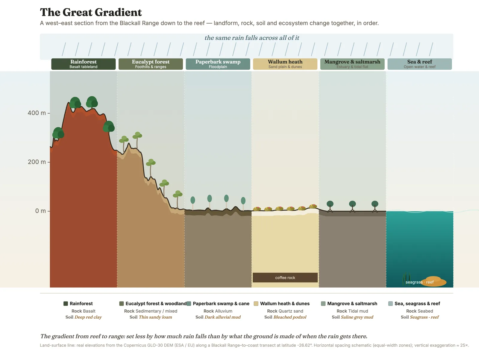
Mount Tinbeerwah is a lookout that teaches the whole book in one turn of the head. It is a volcanic plug — the hard, eroded root of an old volcano, left standing proud as the softer rock around it wore away (Willmott 2007) — and a short walk leads up its bare rhyolite summit to one of the great vantages of the coast. From the top you can read almost the entire gradient at a glance: the sand country and the tea-dark lakes running north toward Cooloola, the sea beyond the dunes, the river valleys and the hinterland ranges climbing away inland. It is the clearest place on the coast to see the argument this whole resource makes — that the reef and the range are one connected country, sorted by rock and soil and water down a single slope (see the-gradient-rule), with the poorest sand carrying the richest heath (see poverty-diversity).
And it is a place where reading the country changed its history. By the middle of the twentieth century the bright, "useless" sand of Cooloola — the very poverty that breeds the wallum's spring richness — was wanted for the heavy minerals in its dunes, and sand-mining leases loomed. It was on a botanising trip to the top of Mount Tinbeerwah that the Caloundra wildflower painter Kathleen McArthur and the poet Judith Wright, two of the founders (in 1962) of the Wildlife Preservation Society of Queensland, resolved that Cooloola had to be saved. What followed became one of the founding campaigns of Australian conservation: from 1969 McArthur ran it as a national letter-writing drive, something like a hundred thousand protest cards, and they won — Cooloola was gazetted as national park in December 1975, saving not just the scenery but the nearly million-year soil chronosequence that has taught the world how soils and ecosystems age. (The full story is in saving-cooloola.)
That is why the mountain is more than a good view. Stand where they stood, look out over the sand and the lakes and the sea, and you are looking at the exact country that was nearly dug up — and at the reason it was not. The vantage that lets you read the whole gradient is the same vantage that let two people read its value against the grain of their time, and act before it was gone. Reading the country, from up here, is not an idle skill. It is the thing that saved what you are looking at.
Concepts this teaches — follow a thread
The gradient rule (substrate writes the country)Why the poorest ground grows the richest flora
Sources for this guide — followable
- Willmott, W. (2007). Rocks and Landscapes of the Sunshine Coast (2nd ed.). Geological Society of Australia. (Local basement = Amamoor & Booloumba Beds; North Arm Volcanics; Landsborough Sandstone. NB: Neranleigh–Fernvale Beds are the Gold Coast/Brisbane equivalent, not the Sunshine Coast basement.) — Volcanic plugs of the Sunshine Coast hinterland — the eroded roots of old volcanoes (Tinbeerwah among the region's rhyolitic/volcanic high points).
Test yourself →
Forget the whole coast for a moment and crouch at one small creek bank, barely two metres from top to bottom. Up on the lip, thin sandy grit carries hard-leaved heathy shrubs; a stride lower, where silt and leaf litter have gathered into a richer, damper pocket, a little knot of soft-leaved rainforest plants has taken hold. Same creek, same rain, same air — only the ground changes across two metres. What are you reading?
This is the whole-coast rule transferred to a scale of metres. On the lip, the ground is thin, freshly-stripped, leached grit — poor soil, so hard-leaved heath. A stride down, weathered fines, silt and leaf litter have collected into a deeper, damper, richer pocket — better soil, so soft-leaved rainforest plants. Same rain, same air; only the substrate changed, and the vegetation changed with it. The rule that sorts rainforest from heath across the coast is doing the identical work across one creek bank, because it was never about size — it is about the ground. The near-miss says the rule only 'works' at the whole-coast scale; that mistakes a principle for a map legend. Coincidence cannot explain a pattern that lines up so exactly with the soil, and the lower plants are a different, richer-ground community, not young heath. Read the ground at whatever scale you find it. (Ch 4; Ch 7.)
A restoration crew spreads fertiliser on a patch of degraded wallum heath to 'boost' the native plants back to health. Predict what happens to the *number of plant species* on that patch over the next few years — and why.
This is the poverty-diversity rule run forwards as a management consequence, and it catches good intentions. The heath's diversity is *held up by* its poverty: strip that away with fertiliser and a handful of fast, greedy growers monopolise the windfall, overtop the low specialists and shade them out — richness collapses. The near-miss ('richness rises — more food, more plants') is the intuitive answer and the wrong one; you cannot fertilise a heath back to health, and nutrient run-off from farms and gardens is a genuine threat to the wallum, not a gift. (Ch 4; Ch 9.) The mechanism is best-evidenced at Jurien Bay, WA (Zemunik et al. 2015 — the principle, not a Cooloola measurement).
Cited · traceable Last checked 2026-07. Deep-tier claims rest on, and were checked against, Willmott 2007, Rocks and Landscapes of the Sunshine Coast (volcanic plugs / hinterland volcanic rock). Grounded in Ch 17 (An environmental history) — 'The fight for Cooloola' sidebar and Notes, verified June/July 2026: on a botanising trip to the top of Mount Tinbeerwah, Kathleen McArthur and Judith Wright (WPSQ founders, 1962) resolved to save Cooloola; national letter-writing campaign of ~100,000 protest cards from 1969; Cooloola national park gazetted December 1975, protecting the ~million-year soil chronosequence. The gradient-rule / poverty-diversity framing per Ch 7 and Ch 4/9. Cross-reference: saving-cooloola. Verified July 2026. — every source is listed below and followable. Grounded in Same Sky, Different Ground.