A place
Noosa headland (coastal rocky reefs)
The volcanic-and-sedimentary headland at Noosa, and the rocky reefs beneath it, where the warm current lays tropical coral against cool-water sponge on one rock — a two-oceans reef under a much-loved, much-walked shore.
- On the gradient
- The marine edge of the gradient — headland and rocky reef where the range meets the sea
- Rock
- Volcanic and sedimentary headland rock (hard promontory resisting the sea)
- Soil
- Rocky headland and submerged rock reef; adjoining marine sand
- A rocky headland reef in clear water — hard bottom, not sand
- Tropical hard coral and cool-water sponges/seaweeds sharing one boulder
- Bright reef fish moving in pairs over the rock
- A whale spout offshore in winter
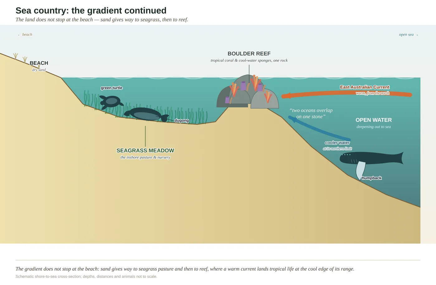
The Noosa headland is the rocky point at the end of Noosa National Park, where the land runs out into the sea as bare stone. Under the water off it, the same warm current that made a cartoon turtle famous carries tropical animals down from the north, and they settle here at the very edge of where they can live — sharing the reef with cool-water sponges and seaweeds. It is a two-oceans reef, and one of the most visited stretches of coast in Queensland sits right on top of it.
Walk to the end of Noosa National Park and the land runs out into the sea as bare rock. The soft sand beaches on either side have been chewed and rebuilt by the waves a thousand times over, but the headland stands because it is made of harder stuff — a promontory of volcanic and sedimentary rock that the sea has not managed to shift. It is one of the most walked, most photographed, most loved stretches of coast in Queensland, and almost everyone who stands on it is looking at the view. The better story is under the water.
Because the same hard rock carries on below the waterline as a reef, and that reef sits at one of the more interesting addresses in Australian marine biology. The East Australian Current — the warm southward flow made briefly famous by a cartoon turtle — runs down this coast carrying tropical water and the drifting young of tropical fish and corals spawned far to the north. Many of them settle right here, at the very southern edge of where warm-water animals can survive, while cool-water species from the temperate south reach their northern edge close by. So the headland reef is a collision of two oceans: hard coral, unmistakably tropical, growing within a fin’s-length of the leathery sponges and seaweeds of the cool south, each near the limit of what it can bear.
That overlap is what makes the reef sensitive. A community living at the edge of its members’ tolerances feels every shift in the water keenly, and the warming now reaching down the current presses hardest here. Which is the quiet tension of the place: the two-oceans reef is one of the true glories of the coast, and it lies directly beneath one of its busiest headlands. Read from the top, it is a lookout. Read from the water, it is a gauge of how fast the sea is changing — and a test of whether a place this loved can also be left well enough alone.
In depth — the mechanism
The Noosa headland is the seaward end of the coastal range, a promontory of hard volcanic and sedimentary rock that resists the sea where the soft sand beaches on either side do not — which is exactly why it stands out as a headland at all. Below the waterline the same hard rock carries a rocky reef, and that reef sits in the two-oceans overlap (see two-oceans-overlap). The East Australian Current runs warm tropical water and tropical larvae down the coast; the headland reef lies at or near the southern limit for many of those warm-water species, while cool-water species from the temperate south reach their northern limit close by. The result is the improbable subtropical mongrel of the SE Queensland reef: tropical hard corals and bright reef fish sharing the rock with the sponges and leathery seaweeds of the cool south, each near the edge of what it can stand.
Two honest calibrations. (1) The temperate element here is chiefly sponges and seaweeds, not the dense kelp of cooler NSW reefs — kelp is marginal this far north, so read "cool-water" as sponge-and-algae, not kelp forest. (2) The headland's reef is a warm-temperate/subtropical overlap reef, not a tropical coral reef in the Great Barrier sense — corals are present but do not build the massive framework of the tropics. The other defining fact of this place is human: Noosa National Park headland is among the most heavily visited pieces of coast in Queensland, so the reef beneath it carries the pressure of that traffic — trampling on the intertidal rock, boat and snorkel visitation, and the run-off and warming that press hardest on a community already living at the edge of its tolerances. A two-oceans reef is a sensitive gauge of a changing sea; putting one under a much-loved headland makes it a test of how gently a crowd can read its own favourite place.
Concepts this teaches — follow a thread
Sources for this guide — followable
- McPhee, D. (2017). Environmental History and Ecology of Moreton Bay. CSIRO Publishing. — Rocky-reef communities and EAC-driven tropical–temperate overlap on the SE Queensland coast.
- Davie, P. (1998). Wild Guide to Moreton Bay. Queensland Museum. — Regional marine natural history of the headland reefs and their fauna.
Test yourself →
You duck under with a mask off a rocky headland in clear water. On a single boulder, tropical hard coral is growing within a fin's-length of leathery cool-water sponges and seaweeds; butterflyfish move past in pairs; and out beyond the break, in winter, a whale spouts. What country are you reading, and what put this improbable mix on one rock?
Cues: A rocky headland reef in clear water — hard bottom, not sand · Tropical hard coral and cool-water sponges/seaweeds sharing one boulder · Bright reef fish moving in pairs over the rock · A whale spout offshore in winter
The tell is the mix on one rock. Hard bottom off a headland is reef, not seagrass (which grows on sheltered sand), and tropical coral sitting right beside cool-water sponges and seaweeds is the signature of the two-oceans overlap. The East Australian Current carries warm water and tropical larvae down the coast to the very southern edge of where they can live, while temperate species reach their northern edge close by — so both share the reef, each near its limit. It is not a Great Barrier-scale coral reef (the water is not uniformly warm; corals are present but do not build the tropical framework), and it is not a kelp forest (kelp is marginal this far north — the temperate element here is sponges and seaweeds). The winter whale spout is the humpback migration passing offshore. (Ch 14.)
On the headland reefs of the Sunshine Coast, tropical species (corals, reef fish) live on the same rock as temperate species (sponges, seaweeds, cool-water fish). What best explains why both faunas share this one stretch of coast?
This coast is a biogeographic overlap, and the current is what makes it one. The East Australian Current runs warm tropical water and the drifting larvae of tropical fish and corals down the Queensland coast; many settle here, at or near the southern limit of where warm-water species can live. Cool-water species from the temperate south reach their northern limit close by. So the two faunas meet and mingle on the same reef, each near the edge of its tolerance — which also makes the community a sensitive gauge of a warming sea. It is not a uniformly tropical outpost of the Great Barrier Reef (the water is not that warm, and corals here do not build the tropical framework), the species are not shipping introductions, and they are genuinely different animals, not one changing with the season. (Ch 14.)
Cited · traceable Last checked 2026-07. Deep-tier claims rest on, and were checked against, McPhee 2017, Environmental History and Ecology of Moreton Bay; Davie 1998, Wild Guide to Moreton Bay; Ch 14 sea-country Notes (EAC overlap, temperate element = sponges/seaweeds not kelp; corals present but not GBR-scale — verified July 2026) — every source is listed below and followable. Grounded in Same Sky, Different Ground.