A place
Point Cartwright & the Mooloolaba rocky reef
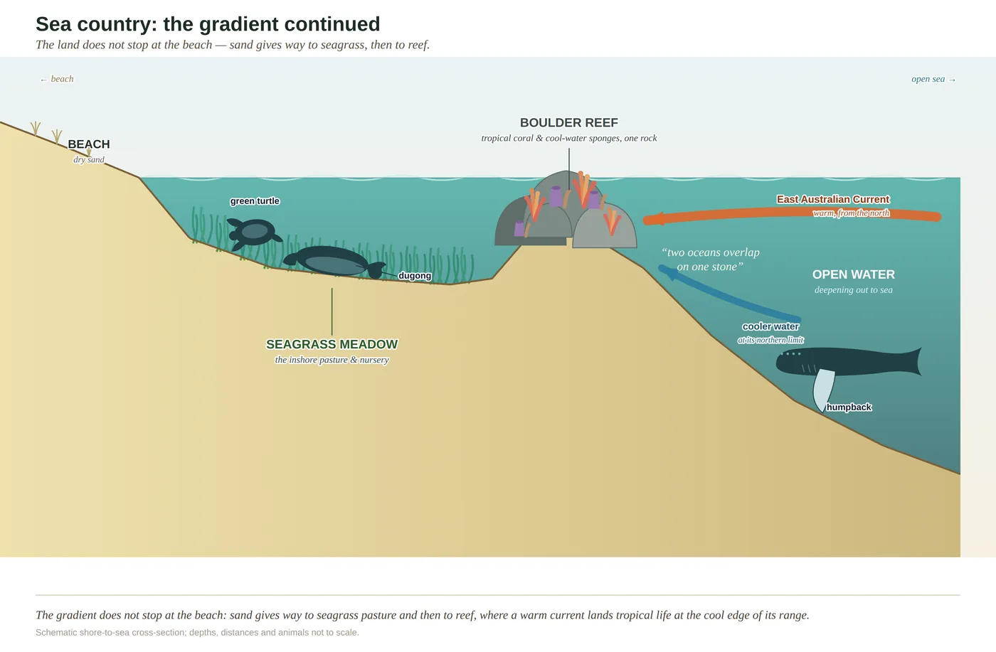
A worked two-oceans reef at the range's seaward edge, where the warm current lays tropical coral and reef fish against the sponges and seaweeds of the cool south on the same headland rock — with seagrass in the sheltered river mouth behind.
- On the gradient
- The seaward edge of the gradient — a headland rocky reef in the two-oceans overlap, where the land goes under the sea
- Rock
- Rocky headland and offshore shoals at the mouth of the Mooloolah River — hard-bottom reef at the seaward edge of the coast
- Soil
- Rock reef (no soil); seagrass on soft sand in the sheltered river mouth behind the point
- A rocky headland reef in clear water — hard bottom, not sand
- Tropical hard coral and cool-water sponges/seaweeds sharing one boulder
- Bright reef fish moving in pairs over the rock
- A whale spout offshore in winter
Point Cartwright is the rocky headland at the mouth of the Mooloolah River, and the shoals around it and off nearby Mooloolaba are one of the coast's best two-oceans reefs. The warm East Australian Current runs tropical fish and coral down onto the rock, where they live alongside the sponges and seaweeds of the cooler south — two oceans' worth of life on one headland. Behind the point, in the sheltered river mouth, grow seagrass meadows. It is the seaward edge of the land's gradient, where the rock finally goes under the water and a mongrel community of warm and cool takes over.
Point Cartwright is the low rocky headland at the mouth of the Mooloolah River, and if you want to feel where the land’s great gradient finally runs out, take a mask down to the shoals around it, or to the rocky reef off Mooloolaba next door. Duck under, and the first surprise is that the reef is not one community but a collision of two. The East Australian Current — the warm southbound flow made briefly famous by a cartoon turtle — pours tropical water and the drifting young of tropical fish and corals down the coast and drops them here, near the very southern edge of where warm-water animals can live. So on a single boulder you will find hard coral, unmistakably tropical, growing within a fin’s-length of the sponges and leathery seaweeds of the cool south, with bright butterflyfish and damselfish mixing in among the sober, stouter fish of colder water. It is a mongrel of two oceans, and all the finer for it.
Two things are worth reading correctly. The first is that cool-water half: here it is sponge and seaweed, not the dense kelp forest you would meet on a reef down in New South Wales — kelp barely hangs on this far north, and its absence is not a gap but a clue to exactly where on the map you are standing. The second is what the overlap makes the reef: a gauge. Every animal on it is living at the edge of what it can bear, tropical and temperate alike, and a community poised on its tolerances feels a warming sea before anywhere else does. Watch this rock over the years and you are watching the boundary between two oceans move.
Then swim in behind the point, into the sheltered mouth of the river, and the sea changes its mind. The bare hard rock gives way to soft sand, and on the sand grows seagrass — the pale, flowering pasture that feeds and shelters the inshore web. Reef and meadow are two faces of one sea country, and Point Cartwright is the hard, seaward face of it: the last of the range, gone under the waves.
In depth — the mechanism
Point Cartwright is where the land's gradient runs off the end of the rock and keeps going underwater. The headland stands at the mouth of the Mooloolah River, and the shoals ringing it — and the rocky reefs off Mooloolaba beside it — sit at one of the more interesting addresses in Australian marine biology, because this is where two oceans of species meet on the same stone (see two-oceans-overlap). The engine is a current. The East Australian Current runs warm tropical water and, with it, the drifting larvae of tropical fish and corals spawned far to the north down the coast, and many of them settle here, at or near the southern limit of where warm-water species can survive. Cooler-water species from the temperate south reach their northern limit not far away. So on a single boulder, hard coral grows within a fin's-length of the leathery seaweeds and sponges of the cool south, and bright tropical reef fish — butterflyfish, damselfish, a parrotfish crunching at the rock — mingle with the stouter wrasses of colder water. It is a community with no business existing in one place, assembled by the current out of two oceans, and richer for the improbability.
One calibration the book insists on: read the temperate element here as sponge and seaweed, not kelp. The dense kelp forests belong to the cooler reefs of New South Wales; this far north kelp is marginal, and the cool-water half of the overlap is carried by sponges, soft corals and leathery brown algae instead (McPhee 2017; Booth et al. 2007). That distinction matters, because the whole point of an overlap reef is that its members live at the very edge of what they can bear — and a community strung along its tolerances feels every warming of the water first. As marine heatwaves reach down the current, the boundary shifts: tropical species nudge further south, and the cool-water ones that have nowhere cooler to go are pressed. The headland reef is, in its quiet way, a gauge of how fast the sea is changing, read in the slow reshuffling of who lives on the rock.
Swing in behind the point and the sea changes its handwriting. Where the reef is bare hard-bottom rock — no place for a meadow — the sheltered mouth of the Mooloolah carries the other face of the same sea country: seagrass in the soft sandy shallows, the pasture and nursery that feeds the inshore web (see seagrass-meadows). Reef and meadow are two halves of one whole, and Point Cartwright is the hard face of it — the seaward edge of the great gradient, the last of the range going under the waves.
Concepts this teaches — follow a thread
Two oceans on one rock (the tropical–temperate overlap)Seagrass meadows (the inshore pasture and nursery)
Sources for this guide — followable
- McPhee, D. (2017). Environmental History and Ecology of Moreton Bay. CSIRO Publishing. — EAC-driven tropical–temperate overlap on the SE Queensland coast; local rocky-reef communities off Point Cartwright/Mooloolaba; temperate element = sponges/seaweeds, not kelp.
- Davie, P. (1998). Wild Guide to Moreton Bay. Queensland Museum. — Regional marine natural history of the headland reefs and their fauna.
- Booth, D.J., Figueira, W.F., Gregson, M.A., Brown, L. & Beretta, G. (2007). Occurrence of tropical fishes in temperate southeastern Australia: role of the East Australian Current. Estuarine, Coastal and Shelf Science 72(1–2): 102–114. (Tropical fish larvae carried south by the EAC settle in temperate SE Australia — the EAC tropical–temperate FISH overlap behind two-oceans-overlap; Ch 14.) — Tropical reef-fish larvae carried south by the East Australian Current, settling near their southern limit in temperate SE Australia — the fish side of the two-oceans overlap.
Test yourself →
On the headland reefs of the Sunshine Coast, tropical species (corals, reef fish) live on the same rock as temperate species (sponges, seaweeds, cool-water fish). What best explains why both faunas share this one stretch of coast?
This coast is a biogeographic overlap, and the current is what makes it one. The East Australian Current runs warm tropical water and the drifting larvae of tropical fish and corals down the Queensland coast; many settle here, at or near the southern limit of where warm-water species can live. Cool-water species from the temperate south reach their northern limit close by. So the two faunas meet and mingle on the same reef, each near the edge of its tolerance — which also makes the community a sensitive gauge of a warming sea. It is not a uniformly tropical outpost of the Great Barrier Reef (the water is not that warm, and corals here do not build the tropical framework), the species are not shipping introductions, and they are genuinely different animals, not one changing with the season. (Ch 14.)
You duck under with a mask off a rocky headland in clear water. On a single boulder, tropical hard coral is growing within a fin's-length of leathery cool-water sponges and seaweeds; butterflyfish move past in pairs; and out beyond the break, in winter, a whale spouts. What country are you reading, and what put this improbable mix on one rock?
Cues: A rocky headland reef in clear water — hard bottom, not sand · Tropical hard coral and cool-water sponges/seaweeds sharing one boulder · Bright reef fish moving in pairs over the rock · A whale spout offshore in winter
The tell is the mix on one rock. Hard bottom off a headland is reef, not seagrass (which grows on sheltered sand), and tropical coral sitting right beside cool-water sponges and seaweeds is the signature of the two-oceans overlap. The East Australian Current carries warm water and tropical larvae down the coast to the very southern edge of where they can live, while temperate species reach their northern edge close by — so both share the reef, each near its limit. It is not a Great Barrier-scale coral reef (the water is not uniformly warm; corals are present but do not build the tropical framework), and it is not a kelp forest (kelp is marginal this far north — the temperate element here is sponges and seaweeds). The winter whale spout is the humpback migration passing offshore. (Ch 14.)
Cited · traceable Last checked 2026-07. Deep-tier claims rest on, and were checked against, McPhee 2017, Environmental History and Ecology of Moreton Bay; Davie 1998, Wild Guide to Moreton Bay; Booth et al. 2007 (EAC transport of tropical reef-fish larvae to temperate SE Australia). Grounded in Ch 14 (sea country) — 'Down on the reef': named local dive/snorkel sites Point Cartwright/Mooloolaba rocky reefs; EAC two-oceans overlap of tropical coral + reef fish with temperate sponges/seaweeds; explicit correction that the temperate element is sponges/algae, NOT kelp (kelp marginal in SE Qld); range shifts under warming/marine heatwaves; seagrass as the sheltered-water counterpart. Verified July 2026. — every source is listed below and followable. Grounded in Same Sky, Different Ground.