The gradient
The great gradient (reef to range)
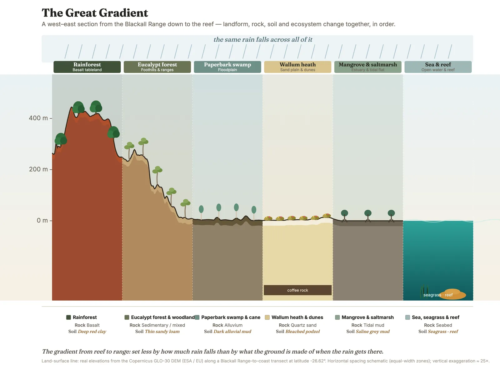
The reef-to-range transect as one ordered sequence — six worlds set in order by the ground beneath them, and a grammar you can read at any scale from the whole coast to a single creek bank.
- On the gradient
- The whole reef-to-range transect — the spine every other unit projects onto
- Rock
- Full transect: Cenozoic basalt (range) → sedimentary basement → Quaternary alluvium and coastal sand → tidal mud
- Soil
- Red Ferrosol (range) → mixed sedimentary loams → alluvium → leached podzol (sand) → estuarine mud
- Dunes that get demonstrably older the further inland you walk
- Tall eucalypt forest standing on the middle-aged sand
- Giant bleached podzols on the oldest dunes, plunging metres deep
- The same sand, same rain, same air the whole way — only time changes
Drive from the range down to the sea and you pass through six different worlds — rainforest, eucalypt forest, floodplain, wallum, dunes, estuary — one after another. They line up in that order not because of the rain, but because of what the ground is made of. Learn the order and you can guess what will grow before you get there.
Here is a forty-minute drive that doubles as a time machine and a field guide. Point the car down the hill from Maleny to Mooloolaba and, before your coffee has gone cold, you will have crossed more than three hundred million years of rock and passed through every major ecosystem the Sunshine Coast holds. Most people make this drive thinking about lunch. Learn to read it instead, and you will have understood the entire place.
Start at the top, in the deep green hush of the Blackall Range rainforest, on rich chocolate-red basalt soil. Point the car downhill and within minutes the rainforest thins and surrenders to tall eucalypt forest, the canopy lifting and opening. Lower still, the country flattens into old floodplain — cane paddocks now, with the occasional lonely forest red gum left standing in a field like the last guest at a party nobody told it had ended. Cross the river and the very ground changes its mind and turns to sand: paperbark swamps in the hollows, flower-strewn wallum heath on the rises, then the dunes, and finally the mangroves and open water of the river mouth, where the tide breathes in and out, twice a day, forever.
Six worlds, one short drive — and they are not an accident. They are a single, ordered sequence, and the thing that lines them up is not the rain (most of the gradient gets a decent drink) but the ground itself: how deep the soil runs, how many nutrients it holds, and where the water sits or slips away. Rich basalt on the cool, wet range grows rainforest; hungry sand on the warm coast grows heath; mixed sedimentary ground between them grows the open eucalypt forest nine people in ten picture when you say “the Australian bush.”
And here is the part that makes the rule worth learning: it plays at every scale beneath the great slope. Climb almost any hill and you will find the gradient repeated in miniature — dry, fast-draining slopes growing open forest, damp gullies a few steps away growing wet forest toward rainforest. Walk the Cooloola dunes and it is there again, laid out through time rather than up a slope, the forest shrinking to low heath as the sand ages and its phosphorus drains away. Once you have the rule, you never quite look at a hillside the same way again. You see instead a set of answers to a single question the land is forever being asked — what will grow here, given this rock, this soil, this water — and you find that you can very often read the answer before you have taken a step.
In depth — the mechanism
The gradient is the book's organising thesis: geology writes the rules, soils translate them, living things live them out, and people change them. Along the Maleny–Mooloolaba descent the sequence runs, in order, rainforest on basalt-derived red clay (Ferrosol) → tall eucalypt forest and woodland on mixed sedimentary/loamy ground → floodplain and paperbark swamp on alluvium → wallum heath on leached sand → mangrove/saltmarsh estuary on tidal mud → sea country offshore. Rainfall is nearly constant across most of it; the sorting variable is substrate — soil depth, nutrient status (above all the N–P asymmetry, with phosphorus the near-irreplaceable limiting currency), and hydrology. Three rocks, three destinies: rich basalt → rainforest, hungry sand → heath, middling sedimentary ground → open eucalypt forest (Willmott 2007 for the regional rock-to-landform basis).
The rule is scale-independent, which is what turns it from a scenic drive into a tool. It repeats on one hill (Mt Ninderry: dry, fast-draining exposed slopes grow open eucalypt forest; deeper, damper gullies grow wet forest toward rainforest), across one dune field (Cooloola: tall forest on middle-aged sand giving way to low heath on the oldest, most phosphorus-depleted dunes — Thompson 1981; the strategy/species-diversity climb best-evidenced at Jurien Bay, WA, Zemunik et al. 2015), and even across the two banks of one creek where one is basalt and the other sand. Reading the country is running the rule backwards — from the plant you can see to the ground that explains it — and reading its exceptions: vegetation that doesn't match the ground (a lone relict forest red gum in a cane paddock) is telling you what happened, not what the ground is; the soil would still grow forest, but people changed it.
Concepts this teaches — follow a thread
The gradient rule (substrate writes the country)Why the poorest ground grows the richest floraThe nitrogen–phosphorus asymmetry
Sources for this guide — followable
- Willmott, W. (2007). Rocks and Landscapes of the Sunshine Coast (2nd ed.). Geological Society of Australia. (Local basement = Amamoor & Booloumba Beds; North Arm Volcanics; Landsborough Sandstone. NB: Neranleigh–Fernvale Beds are the Gold Coast/Brisbane equivalent, not the Sunshine Coast basement.) — Rocks and Landscapes of the Sunshine Coast — the regional rock-to-soil-to-landform basis.
- Walker, T.W. & Syers, J.K. (1976). The fate of phosphorus during pedogenesis. Geoderma 15: 1–19. — Soil nutrient decline as the substrate driver behind the vegetation sequence.
- Thompson, C.H. (1981). Podzol chronosequences on coastal dunes of eastern Australia. Nature 291: 59–61. — The Cooloola chronosequence — the rule at the scale of one dune field.
- Zemunik, G., Turner, B.L., Lambers, H. & Laliberté, E. (2015). Diversity of plant nutrient-acquisition strategies increases during long-term ecosystem development. Nature Plants 1: 15050. (Jurien Bay chronosequence, WA — the principle of rising strategy diversity; NOT a Cooloola study. Earlier draft mis-cited as "Laliberté et al., Cooloola".) — Strategy/species-diversity peak on the poorest soils (Jurien Bay, WA — the principle).
Test yourself →
You walk inland across the Cooloola dunes. The dunes get demonstrably older the further back you go; near the beach the sand carries tall eucalypt forest. On the oldest dunes, far inland, what do you predict is growing — and why is it not even taller forest?
Cues: Dunes that get demonstrably older the further inland you walk · Tall eucalypt forest standing on the middle-aged sand · Giant bleached podzols on the oldest dunes, plunging metres deep · The same sand, same rain, same air the whole way — only time changes
This is the gradient rule at the scale of one dune field: substrate, not rainfall, decides. Phosphorus comes only from rock and is never replaced, so on the oldest dunes it has all but leached away and no tall tree can be built. The mass of the vegetation peaks on the middle-aged dunes and falls to low heath on the oldest — while the variety of plants climbs to its maximum there. Same rule, smaller scale. (Ch 4; Ch 7.) Note: the species-richness peak on the oldest soils is the general chronosequence pattern, best-evidenced at Jurien Bay, WA (Zemunik et al. 2015), not a Cooloola-specific measurement.
Nitrogen can be topped up from the air by microbes and plants; phosphorus can only ever come from weathering rock. On an ancient soil, hundreds of thousands of years old, which nutrient runs short for good — and what does that mean for the country it can grow?
This is the hinge the whole Cooloola story swings on. Nitrogen-fixing organisms bank nitrogen out of thin air; nothing can do that for phosphorus. Once the original rock's phosphorus has weathered out and washed to sea, there is no resupply — so the oldest soils only ever get poorer, and the tall forest they once carried gives way to low heath. Along the Cooloola dunes, total phosphorus in the topsoil falls by roughly 90% from the youngest to the oldest sand. (Ch 4.)
Cited · traceable Last checked 2026-07. Deep-tier claims rest on, and were checked against, Willmott 2007, Rocks and Landscapes of the Sunshine Coast (2nd ed.); Ch 7 gradient synthesis; Thompson 1981 and Zemunik et al. 2015 for the chronosequence claims — every source is listed below and followable. Grounded in Same Sky, Different Ground.