An ecosystem
The tidal estuary
Mangrove, saltmarsh and seagrass sorted into bands by the salt and the tide — the muddiest, least-loved ground on the coast, and the most productive.
- On the gradient
- The bottom of the gradient — tidal flats where river meets sea
- Rock
- Holocene estuarine mud and river alluvium
- Soil
- Waterlogged, sulphurous intertidal mud over buried sulfidic sediment
- Soft grey mud, sulphurous underfoot, not firm ground
- Thousands of slender pencil-thin roots standing upright out of the mud
- A tide line marking how far the salt water climbs
- Behind the trees, an open salt-crusted flat of low succulents
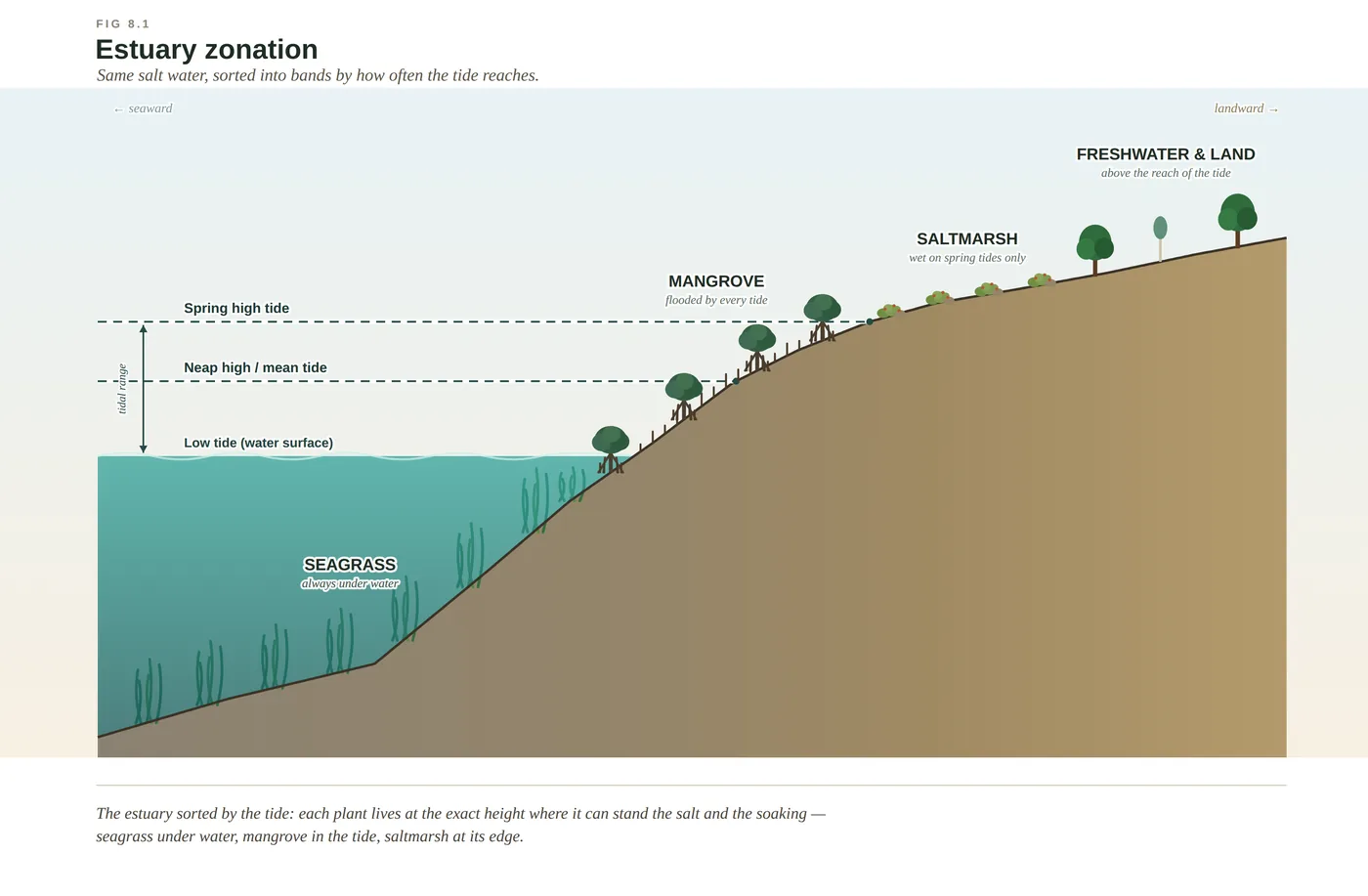
The tidal flats where a river meets the sea look like wasteland: grey mud, a sulphur smell, trees standing in the water. They are in fact the most productive ground on the whole coast — the nursery the fisheries are built on, a sea wall that repairs itself, and one of the densest carbon stores on Earth. And the plants are not scattered at random. Seagrass, mangrove and saltmarsh each live at the one tidal height where they can just stand the salt and the soaking.
For two centuries the standard response to a mangrove swamp was to drain it, fill it and build something tidier on top, and it was one of the great misreadings of the Australian coast. The tidal flats where the rivers meet the sea — the mangroves, the saltmarsh behind them, the seagrass in the shallows — are muddy, sulphurous and genuinely hard to love. They are also the most productive ground on the whole gradient, and once you know what you are looking at, the least deserving of contempt.
To read the estuary you have to throw out the idea of solid ground and think in tides. Twice a day the salt water rushes in and drains away, so a plant rooted here is alternately drowned in seawater and left high and dry, standing in mud so airless it turns black a few centimetres down. By every normal botanical reckoning nothing should grow here at all. And yet a handful of extraordinary trees — the mangroves, a guild of unrelated species that have each cracked the same impossible problem — not only survive it but build the place, trapping mud tide after tide until they raise new land out of muddy water and reach steadily out into the channel.
The three bands are one machine, run by the moon. The tide lays down the fine mud the rivers carry off the land; the mangroves hold it against the current and add their vast fall of leaves; the leaf-eating crabs shred those leaves into detritus; and the detritus, worked over by microbes, feeds the worms and prawns and juvenile fish among the roots, which in turn feed the mud crabs, the herons and the boats. The saltmarsh baking above the tideline and the seagrass meadow in the clear shallows run the same economy at their own heights, and all three bury carbon in the airless mud as they go. None of it is pretty in the postcard sense, and all of it is doing more for the coast’s fish, floods, climate and birds than the manicured foreshore we so often put in its place. The engine room of the whole coast was hiding, all along, in the place we held our noses and looked away from.
In depth — the mechanism
The estuary is the gradient rule run at its steepest and fastest — the great slope of the coast squeezed into a few hundred metres and driven by the tide instead of the rock. One variable does most of the sorting: how often the salt water reaches. Seagrass holds the permanently drowned ground below the tide; mangrove takes the band flooded and drained twice a day; saltmarsh sits on the higher flats the spring tides reach only now and then. Each band is the set of specialists that can stand a little more salt and soaking than the band above it — the same tolerance ladder as the dunes, read here in salt rather than poverty (see estuarine-zonation).
Two problems make the mangrove band nearly uninhabitable, and the mangroves solve both (see mangrove-salt-strategies). Salt is simple poison, drawing water out of living tissue; the grey mangrove (Avicennia marina, the dominant species on this coast) filters most of it out at the root and sweats the rest through glands on its leaves, so the foliage can crust faintly with sea salt on a still day. The mud is the second problem: waterlogged, it holds almost no oxygen and goes black and sulphurous a few centimetres down, so the grey mangrove does not try to breathe through it at all but sends up thousands of slender pneumatophores — pencil roots that stand out of the mud and pipe air to the drowned roots below.
The whole system runs on dead leaves, not on sunlight caught by green pasture the way a paddock does. A mangrove forest sheds an enormous fall of litter; the sesarmid leaf-eating crabs drag it underground, shred it and pass it out as fragments that microbes finish, and that detritus is the base of the food web that fattens the prawns and fish. It is why the estuary is a nursery — most of the region's fish and prawns spend their vulnerable juvenile stage hidden among the roots and the seagrass — so draining one demolishes a maternity ward whose losses turn up years later and kilometres away as empty nets (McPhee 2017). The airless mud does one more quiet job: because decay all but stops without oxygen, every buried leaf and root locks its carbon away as "blue carbon," gram for gram far outpacing even rainforest.
Two honest calibrations carried from the book. (1) The blue-carbon advantage over rainforest is well established in kind, but specific per-hectare sequestration figures for these particular wetlands are not settled enough to quote — kept qualitative. (2) The dugong that graze the seagrass of the wider bay and the Pumicestone Passage are a nationally significant, strongly seasonal population, not a fixed headcount: Lanyon's 1995 aerial surveys ranged from several hundred to about a thousand across the year (Lanyon 1995). Protect the seagrass and you keep the dugong; shade it out with dirty water and they simply starve.
Concepts this teaches — follow a thread
Estuarine zonation (the tide sorts the bands)How a mangrove beats salt and mudThe gradient rule (substrate writes the country)
Sources for this guide — followable
- Leiper, G. et al. (2022). Mangroves to Mountains (3rd ed.). Native Plants Queensland. — Regional mangrove, saltmarsh and seagrass flora (Mangroves to Mountains, 3rd ed.).
- McPhee, D. (2017). Environmental History and Ecology of Moreton Bay. CSIRO Publishing. — Bay ecology — estuarine nursery role, seagrass, fisheries and threats.
- Davie, P. (1998). Wild Guide to Moreton Bay. Queensland Museum. — Regional estuarine and mangrove natural history (Wild Guide to Moreton Bay).
- Dugong: Moreton Bay supports a nationally significant, strongly seasonal population — Lanyon's 1995 bi-monthly aerial surveys ranged from ~503 (July) to ~1,019 (January) (Wildlife Research). Correction: earlier drafts attributed this to "Lawler/Marsh ~600–800"; the Moreton Bay survey authority is Janet Lanyon (Lawler/Marsh lead northern/GBR dugong work). Cite the seasonal range or "several hundred to ~1,000," not a fixed 600–800. — Moreton Bay dugong aerial surveys — the seasonal population grazing the seagrass.
Test yourself →
At low tide you walk out onto a wide flat of soft grey mud. Slender pencil-thin roots stand up out of the mud in their thousands around a band of low dark trees; behind them, on higher ground the water only sometimes reaches, is an open flat of low succulents with a faint white salt crust, and a clear tide line marks how far the water climbs. What country are you reading — and why does it look like this?
Cues: Soft grey mud, sulphurous underfoot, not firm ground · Thousands of slender pencil-thin roots standing upright out of the mud · A tide line marking how far the salt water climbs · Behind the trees, an open salt-crusted flat of low succulents
Every cue points to salt and tide. The grey, airless, sulphurous mud and the tide line say you are in the intertidal zone; the thousands of upright pencil roots are pneumatophores — mangrove snorkels that pipe air down to roots drowned in oxygen-starved mud. The salt-crusted succulent flat behind, on ground the tide reaches only occasionally, is saltmarsh. The two bands are sorted by how often the salt water reaches, the estuary's version of the gradient rule. (Ch 8.)
In an estuary, seagrass grows below the tide, mangrove in the tidal band that floods and drains twice a day, and saltmarsh on the higher flats the tide reaches only occasionally — always in that order. What sets the order of the bands?
Estuarine zonation is the gradient rule driven by the tide. The controlling variable is how often the salt water reaches — hydroperiod — running together with salinity and how airless the mud is. Seagrass takes the always-drowned ground, mangrove the twice-daily tidal band, saltmarsh the rarely-flooded flats; each plant holds the one height where it can just stand the conditions and would drown a step seaward or be outcompeted a step landward. It is not richness or height that sorts them, but tolerance. (Ch 8.)
Cited · traceable Last checked 2026-07. Deep-tier claims rest on, and were checked against, Leiper et al. 2022, Mangroves to Mountains (3rd ed.); McPhee 2017, Environmental History and Ecology of Moreton Bay; Lanyon 1995 dugong surveys (Wildlife Research); Avicennia salt-exclusion/excretion & pneumatophores per Ch 8 Notes (verified July 2026) — every source is listed below and followable. Grounded in Same Sky, Different Ground.