A place
Mount Coolum
A domed volcanic monadnock rising straight off the coastal sand plain by the sea — bare rock and skeletal soil carrying a low rock-pavement heath, ringed by wallum and heath on the sand below.
- On the gradient
- Isolated volcanic dome rising off the coastal sand plain, near the sea
- Rock
- Silicic volcanic rock — trachyte/rhyolite dome (monadnock)
- Soil
- Skeletal soil / bare rock on the dome; leached podzolic sand on the surrounding plain
- A steep, isolated peak standing well above a flat plain
- Bare rock at the top — a rounded dome or a cliff face
- Thin, stony soil, barely more than grit in the joints of the rock
- Low, wind-pruned heath and hard, grey-leaved open forest
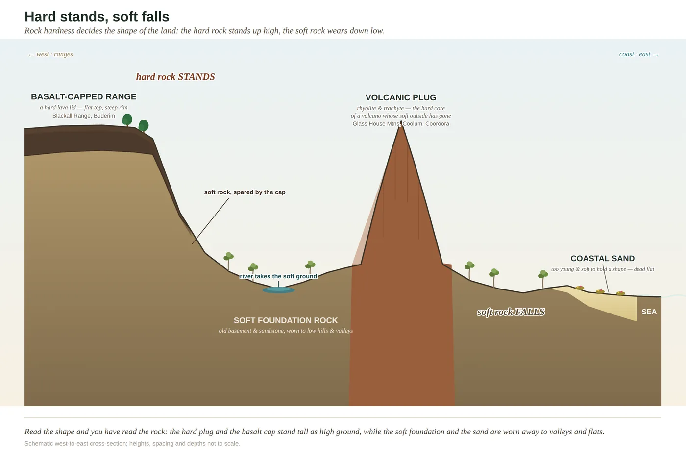
Mount Coolum is a rounded rock dome standing alone right by the coast — the hard core of an old volcano, left behind when the softer land around it wore away. Its soil is barely there, just skeletal grit in the cracks, so it grows a low, tough heath on bare rock; the flat sand plain around it grows wallum heath for a different reason. Two kinds of poor ground meeting at one hill.
Mount Coolum has no business being where it is. You are on the flattest imaginable ground — a wide coastal sand plain running down to the beach, so level it might have been ruled with a straightedge — and out of it, without warning or foothills or any gentle build-up, rises a great rounded dome of bare rock, right there beside the sea. It looks like something dropped from a height onto a billiard table. In a sense it was left rather than dropped: Coolum is the hard trachyte core of an old volcano, and it stands alone because the softer rock and the young sand all around it wore down or lay low while the dome, too tough to rot, stayed put. Geologists have a tidy word for a hard lump left standing proud of a worn-down plain — a monadnock — and Coolum is one of the neatest on the coast.
Climb it and the first thing you meet is the near-total absence of soil. Trachyte weathers with maddening slowness, and the dome’s pavements are so bare and steep that hardly any dirt can gather — just gritty skeletal soil jammed into cracks and shallow hollows. So what grows on top is not a forest but a low, tight, wind-pruned heath and shrubland, hard-leaved and stunted, wedged into the joints of the rock and bent flat by the wind off the sea. Every leaf is stiff and small and defended — the sclerophyll leaf, worn here for the plainest reason of all: there is almost nothing to grow in.
Now walk back down and out onto the flat, and the country stays low and heathy — but for the exact opposite reason. The sand plain wrapping around Coolum’s foot is wallum and coastal heath, and its soil is not missing at all; it is deep, and bleached, and robbed, leached over tens of thousands of years until nothing useful is left. So the dome and its apron both wear the same low, hard-leaved coat, from two entirely unrelated poverties — one because the soil barely exists, the other because it has had everything stolen from it. That is the reading Coolum leaves you with: a hard rock standing in a sea of soft sand, and not a square metre of it rich or sheltered enough to grow a rainforest. The tough, open, hard-leaved heath is telling you so, if you know how to listen.
In depth — the mechanism
Mount Coolum is a monadnock — a hard mass left standing proud of a lowered plain — and a textbook case of hard-stands-soft-falls at the coast's edge. It is a dome of silicic volcanic rock (trachyte/rhyolite), dense and resistant enough to have survived while the softer surrounding rock and the young coastal sand were worn or laid low around it, leaving it rising abruptly off the flat sand plain almost on the beach (Willmott 2007).
It reads as a double lesson in poverty, from two unrelated causes. On the dome itself the trachyte weathers so slowly, and the pavements are so steep and bare, that there is next to no soil — only skeletal grit lodged in joints and hollows. What grows there is a low, wind-pruned rock-pavement heath and shrubland (sometimes called montane heath, though the peak is modest in height), rooted in cracks, hard-leaved and stunted by exposure — the sclerophyll economy at its most extreme, forced here by having almost no soil at all (Leiper et al. 2022). Ring the base and the country stays low and heathy, but for the opposite reason: the surrounding sand plain carries wallum and coastal heath on deep, leached, phosphorus-poor sand. So the dome and its apron both grow heath — one because the soil is skeletal and barely exists, the other because the soil is deep but robbed. The gradient rule reading is that this hard dome standing in a sea of soft sand grows tough, open, hard-leaved country top to bottom: nowhere here is rich or sheltered enough for rainforest, and the vegetation says so at a glance. (The "skeletal soil" is inferred from the bare trachyte pavements and steep exposure, not a site soil survey — a sound reading, flagged as one.)
Concepts this teaches — follow a thread
The gradient rule (substrate writes the country)Sclerophylly (the tough-leaf economy)
Sources for this guide — followable
- Willmott, W. (2007). Rocks and Landscapes of the Sunshine Coast (2nd ed.). Geological Society of Australia. (Local basement = Amamoor & Booloumba Beds; North Arm Volcanics; Landsborough Sandstone. NB: Neranleigh–Fernvale Beds are the Gold Coast/Brisbane equivalent, not the Sunshine Coast basement.) — Mount Coolum as an exhumed trachyte/rhyolite dome (monadnock); differential erosion of the hard dome against the soft coastal plain.
- Leiper, G. et al. (2022). Mangroves to Mountains (3rd ed.). Native Plants Queensland. — Rock-pavement heath and shrubland on the dome; wallum/coastal heath on the surrounding sand plain.
Test yourself →
You've climbed a steep, lone peak that stands high above an otherwise flat plain. Near the top the ground is bare rock — a dome or a sheer face — with only thin, stony grit lodged in the cracks, and what grows is a low, wind-pruned heath and hard-leaved open forest, not a lush closed canopy. What country are you reading, and why does a high peak grow such tough, sparse cover?
Cues: A steep, isolated peak standing well above a flat plain · Bare rock at the top — a rounded dome or a cliff face · Thin, stony soil, barely more than grit in the joints of the rock · Low, wind-pruned heath and hard, grey-leaved open forest
A lone steep peak standing off a flat plain is almost always a hard volcanic core (rhyolite or trachyte) — dense, poorly jointed rock that resisted weathering while the softer ground around it was stripped away and lowered. It was not pushed up; it was left behind (hard stands, soft falls). The catch is that hard, slow-weathering rock yields almost no soil — just thin stony grit — so height here does NOT buy you rainforest. The poverty forces the sclerophyll economy: low wind-pruned heath on the bare pavements and hard-leaved open forest on the slopes. Deep gullies that gather soil and hold damp can green up toward wet forest, but the exposed rock stays tough and sparse. (Ch 3; Ch 11.)
Cited · traceable Last checked 2026-07. Deep-tier claims rest on, and were checked against, Willmott 2007, Rocks and Landscapes of the Sunshine Coast (2nd ed.), coastal plug/dome geology; Leiper et al. 2022, Mangroves to Mountains (3rd ed.), rock-pavement heath and wallum communities; Ch 3 hard-stands-soft-falls; soil on dome flagged as inferred skeletal soil — every source is listed below and followable. Grounded in Same Sky, Different Ground.